Comanche County

Comanche County is a county located in the U.S. state of Oklahoma. As of the 2010 census, the population was 124,098, making it the fourth-most populous county in Oklahoma. Its county seat is Lawton. The county was created in 1901 as part of Oklahoma Territory. It was named for the Comanche tribal nation.
Comanche County is included in the Lawton, OK Metropolitan Statistical Area.
Built on former reservation lands of the Comanche, Kiowa, and Apache in Indian Territory, Comanche County was open for settlement on August 16, 1901, by lottery. The region has three cities and seven towns as well as the Fort Sill military installation and Wichita Mountains Wildlife Refuge. The landscape of the county is typical of the Great Plains with flat topography and gently rolling hills, while the areas in the north are marked by the Wichita Mountains. Interstate 44 and three major US Highways serve the county by ground, while the Lawton-Fort Sill Regional Airport serves the county by air.
Comanche County's economy is largely based in the government sector which consist of half of the county's gross domestic product. The governance of the county is led by a three commission board, which are elected in four year staggered terms. The county is served by several school districts and Cameron University in education as well as three hospitals for health care.
History
The land that is present day Oklahoma was first settled by prehistoric American Indians including the Clovis 11500 BCE, Folsom 10600 BCE and Plainview 10000 BCE cultures. Western explorers came to the region in the 16th century with Spanish explorer Francisco Vásquez de Coronado visiting in 1541. Most of the region during this time was settled by the Wichita and Caddo people. Around the 1700s, two tribes from the North, the Comanches and Kiowas, migrated to the Oklahoma and Texas region.
For most of the 18th century, the Oklahoma region was under French control as Louisiana. In 1803, the Louisiana Purchase by Thomas Jefferson brought the area under United States control. In 1830, Congress passed the Indian Removal Act, which removed American Indian tribes and relocated them to Indian Territory. The southern part of the territory was originally assigned to the Choctaw and Chickasaw until 1867 when the Medicine Lodge Treaty allotted the southwest portion of the Choctaw and Chickasaw's lands to the Comanche, Kiowa, and Apache tribes.
Fort Sill was established in 1869 by Major General Philip Sheridan who was leading a campaign in Indian Territory to stop raids into Texas by American Indian tribes. In 1874, the Red River War broke out in the region when the Comanche, Kiowa and Southern Cheyenne left their Indian Territory reservation. Attrition and skirmishes by the US Army finally forced the return of the tribes back to Indian Territory in June 1875.
In 1891, the United States Congress appointed a commission to meet with the tribal leaders and come to an agreement allowing white settlement in the region. Years of controversy and legal maneuvering ensued before President William McKinley issued a proclamation on July 4, 1901, that gave the federal government control over of surplus Indian land.
Three sites in Kiowa, Caddo and Comanche Counties were selected for county seats with Lawton designated as the Comanche County seat. Non-Indian settlement was opened through an auction of lots beginning on August 6, 1901. In December 1906, the south regions of the county reserved for grazing land reserved for American Indian livestock, Big Pasture, were open for settlement.
In 1910, the western portion of Comanche County and southern part of Kiowa County were used to create the short lived county of Swanson. After a lawsuit brought by Comanche County, Swanson County was dissolved by the Supreme Court on June 27, 1911. In 1912, the southern portion of Comanche County, which at the time extended to the Red River, were used to create the new county of Cotton County.
Geography
According to the U.S. Census Bureau, the county has a total area of , of which is land and (1.3%) is water.
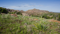
Comanche County lies in an area that is typical of the Great Plains with prairie, few trees, and generally flat topography with gently rolling hills. The north region of the county consists of the Wichita Mountains including Mount Scott and Mount Pinchot the area's highest peaks.
The area consists mostly of Permian Post Oak Conglomerate limestone on the northern sections of the county. In the south sections of the county, Permian Garber Sandstone is commonly found with some Hennessey Group shale. Area creeks including East Cache Creek and West Cache Creek contain deposits of Quaternary alluvium. To the northwest, the Wichita Mountains consist primarily of Wichita Granite Group from the Cambrian Period.
There are three cities in Comanche County. The largest, Lawton is located in the center of the county and is the county seat. According to the US census, the population of Lawton was 96,867 in 2010, which is 78 percent of the county's population. Cache is located to the west of Lawton on US Highway 62 and has a population of 2,796. In the northeast, Elgin is located along Interstate 44 and has a population of 2,156. Several towns dot the county including: Fletcher, Sterling in the northeast, Medicine Park in the north central region, Indiahoma in the west, Geronimo in the southeast, and Chattanooga and Faxon in the southern regions of the county. Also located in Comanche County is Fort Sill. The 90,000 acre instillation is home to the US Army Field Artillery Training Center and the Air Defense Artillery.
Protected areas in Comanche County include the 59,020 acre Wichita Mountains Wildlife Refuge. Established in 1901 the refuge is one of the 546 wildlife refuges throughout the United States to provide a natural habitat for native grazing animals like the Bison, Elk, and Texas longhorn cattle.
Adjacent counties
- Kiowa County (northwest)
- Tillman County (southwest)
- Cotton County (south)
- Stephens County (southeast)
- Grady County (northeast)
- Caddo County (north)
Demographics
As of the census of 2010, there were 124,098 people, 44,982 households, and 30,303 families residing in the county. The population density was 116 people per square mile (45/km2). There were 50,739 housing units at an average density of 47 per square mile (18/km2). The racial makeup of the county was 64.5% White, 17.5% Black or African American, 5.9% Native American, 2.2% Asian, 0.6% Pacific Islander, 3.0% from other races, and 6.5% from two or more races. 11.2% of the population were Hispanic or Latino of any race (7.0% Mexican, 2.4% Puerto Rican, 0.3% Spanish, 0.2% Panamanian).
There were 44,982 households, out of which 36.5% had children under the age of 18 living with them, 48.2% were married couples living together, 14.5% had a female householder with no husband present, and 32.6% were non-families. 27.1% of all households were made up of individuals, and 7.8% had someone living alone who was 65 years of age or older. The average household size was 2.53 and the average family size was 3.07.
In the county, the population was spread out, with 25.1% under the age of 18, 13.6% from 18 to 24, 30.1% from 25 to 44, 23.3% from 45 to 64, and 10.2% who were 65 years of age or older. The median age was 31.3 years. For every 100 females there were 106.2 males. For every 100 females age 18 and over, there were 107.3 males.
The median income for a household in the county was $43,817, and the median income for a family was $51,564. Males had a median income of $37,423 versus $31,913 for females. The per capita income for the county was $21,048. About 14.3% of families and 17.6% of the population were below the poverty line, including 29.4% of those under age 18 and 8.1% of those age 65 or over.
Media
The Lawton Constitution is the only daily newspaper published in the county and has a circulation of 30,000. In addition the Fort Sill newspaper, The Cannoneer, is published weekly primarily for military personnel as well as the newspaper The Cameron Collegian whose main audience is Cameron University students. Additionally, Okie Magazine is a monthly magazine that focuses on news and entertainment in the Southwest Oklahoma area. Fletcher News publishes online news of northeastern Comanche County, including Fletcher, Elgin and Sterling, at http://www.fletcher-news.com.html.
Radio stations in Lawton include, two AM Stations KXCA 1050 and KKRX 1380 as well as several FM stations including, NPR affiliate KCCU 89.3, KZCD 94.1, KMGZ 95.3, KJMZ 97.9, KBZQ 99.5, KLAW 101.3 and KVRW 107.3
Comanche County is located in the Wichita Falls and Lawton Media Market which encompasses 154,450 households with a television, making it the 149th largest in the nation according to Nelson Media Research in 2009–2010. KSWO-TV channel 7, an ABC affiliate, is the only broadcast television station in the area that provides local news. All other major stations including, KFDX-TV 3 (NBC), KAUZ-TV (CBS), and KJTL-TV (Fox) are based in Wichita Falls.
Communities
Cities
- Cache
- Elgin
- Lawton (county seat)
Towns
- Chattanooga
- Faxon
- Fletcher
- Geronimo
- Indiahoma
- Medicine Park
- Sterling
Census-designated places
- Edgewater Park
- Lake Ellsworth Addition
- Lakeside Village
- Lawtonka Acres
Other unincorporated communities
- Bethel
- Meers
- Pumpkin Center
Notable people
Notable residents include country singers: Bryan White, Kelly Willis, and Leon Russell, Grammy nominated jazz trombonist Conrad Herwig, and Flaming Lips drummer Steven Drozd. Notable authors include Pulitzer Prize winning author N. Scott Momaday, poet Don Blanding, and Hugo Award winner, C. J. Cherryh.
Politicians from Comanche County include: U.S. Senator Thomas Gore, US Representatives: Scott Ferris, L. M. Gensman, Toby Morris, and Elmer Thomas. Other politicians include Democratic State Senator Randy Bass and former U.S. Ambassador to Czechoslovakia Julian Niemczyk.
Other notable residents include: World War II Comanche Code Talker Charles Chibitty, World War II Nurse and POW Col. Rosemary H…


![COL Fireworks 2017-07-01 [06]](https://live.staticflickr.com/4033/35505061212_0de6e84e19_m.jpg)
![Johnson's Bakery auction 2018-05-08 [08]](https://live.staticflickr.com/962/42029837441_e61bd4e7a5_m.jpg)
![COL Fireworks 2017-07-01 [21]](https://live.staticflickr.com/4085/35543587491_286fa05e12_m.jpg)


Looking for places related to Comanche County?
Those are other destinations to find places related to Comanche County: