Estado de Baja California

Baja California (Spanish: [ˈbaxa kaliˈfoɾnja]; 'Lower California'), officially the Free and Sovereign State of Baja California (Spanish: Estado Libre y Soberano de Baja California), is a state in Mexico. It is the northernmost and westernmost of the 32 federal entities of Mexico. Before becoming a state in 1952, the area was known as the North Territory of Baja California . It has an area of (3.57% of the land mass of Mexico) and comprises the northern half of the Baja California Peninsula, north of the 28th parallel, plus oceanic Guadalupe Island. The mainland portion of the state is bordered on the west by the Pacific Ocean; on the east by Sonora, the U.S. state of Arizona, and the Gulf of California; on the north by the U.S. state of California; and on the south by Baja California Sur.
The state has an estimated population of 3,769,020 as of 2020, significantly higher than the sparsely populated Baja California Sur to the south, and similar to San Diego County, California, to its north. Over 75% of the population lives in Mexicali (the state's capital city), Ensenada, or Tijuana (the state's largest city). Other important cities include San Felipe, Rosarito, and Tecate. The population of the state is primarily composed of Mestizos, mostly migrants from other parts of Mexico, and as with most northern Mexican states, a large population of Mexicans of Spanish ancestry, and also a large minority group of people with East Asian, Middle Eastern, and indigenous descent. Additionally, there is a large immigrant population from the United States due to its proximity to San Diego and the significant lower cost of living compared to San Diego. There is also a significant population from Central America. Many immigrants moved to Baja California for a better quality of life and the number of higher-paying jobs in comparison to the rest of Mexico and Latin America.
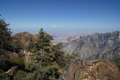
Baja California is the 12th-largest state by area in Mexico. Its geography ranges from beaches to forests and deserts. The backbone of the state is the Sierra de Baja California, where Picacho del Diablo, the highest point of the peninsula, is located. This mountain range effectively divides the weather patterns in the state. In the northwest, the weather is semi-dry and Mediterranean. In the narrow center, the weather changes to be more humid due to altitude. It is in this area where a few valleys can be found, such as the Valle de Guadalupe, the major wine-producing area in Mexico. To the east of the mountain range, the Sonoran Desert dominates the landscape. In the south, the weather becomes drier and gives way to the Vizcaíno Desert. The state is also home to numerous islands off both of its shores. Baja California is also home to Guadalupe Island, the westernmost point of Mexico. The Coronado Islands, Todos Santos islands, and Cedros Island are also on the Pacific shore. On the Gulf of California, the largest island is Angel de la Guarda Island, separated from the peninsula by the deep and narrow Canal de Ballenas.
History
Prehistory and Spanish colonial era
The first people came to the peninsula at least 11,000 years ago. At that time, two main native groups are thought to have been present on the peninsula – the Cochimí in the south, and several groups belonging to the Yuman language family in the north, including the Kiliwa, Paipai, Kumeyaay, Cocopa, and Quechan. These peoples were diverse in their adaptations to the region. The Cochimí of the peninsula's Central Desert were generalized hunter-gatherers who moved frequently; however, the Cochimí on Cedros Island off the west coast developed a strong maritime economy. The Kiliwa, Paipai, and Kumeyaay in the better-watered northwest were also hunter-gatherers, but that region supported denser populations and a more sedentary lifestyle. The Cocopa and Quechan of northeastern Baja California practiced agriculture in the floodplain of the lower Colorado River.
Another group of people was the Guachimis, who came from the north and created much of the UNESCO World Heritage-recognized Sierra de Guadalupe cave paintings. Not much is known about them except that they lived in the area between 100BC and 1300AD.
Europeans reached the present state of Baja California in 1539, when Francisco de Ulloa its east coast on the Gulf of California and explored the peninsula's west coast at least as far north as Cedros Island. Hernando de Alarcón returned to the east coast and ascended the lower Colorado River in 1540, and Juan Rodríguez Cabrillo (or João Rodrigues Cabrilho) completed the reconnaissance of the west coast in 1542. Sebastián Vizcaíno again surveyed the west coast in 1602, but outside visitors during the following century were few.
The Jesuits founded a permanent mission colony on the peninsula at Loreto in 1697. During the following decades, they gradually extended their sway throughout the present state of Baja California Sur. In 1751–1753, the Croatian Jesuit mission-explorer Ferdinand Konščak made overland explorations northward into the state of Baja California. Jesuit missions were subsequently established among the Cochimí at Santa Gertrudis (1752), San Borja (1762), and Santa María (1767).
After the expulsion of the Jesuits in 1768, the short-lived Franciscan administration (1768–1773) resulted in one new mission at San Fernando Velicatá. More importantly, the 1769 expedition to settle Alta California under Gaspar de Portolà and Junípero Serra resulted in the first overland exploration of the northwestern portion of the state.
The Dominicans took over management of the Baja California missions from the Franciscans in 1773. They established a chain of new missions among the northern Cochimí and western Yumans, first on the coast and subsequently inland, extending from El Rosario (1774) to Descanso (1817), just south of Tijuana below the Palóu Line.
In 1804, the Spanish crown divided California into Alta ('Upper') and Baja ('Lower') California at the line separating the Franciscan missions in the north from the Dominican missions in the south. The colonial governors were José Joaquín de Arillaga (1804–1805), Felipe de Goicoechea (1806–1814), and José Darío Argüello (1814April 11, 1822).
Post-independence, 1821–present
Early republic
Mexican liberals were concerned that the Roman Catholic Church retained too much power in the post-independence period and sought to undermine it by mandating the secularization of missions in 1833. In the aftermath of the Mexican American War (1846–1848) and the Treaty of Guadalupe Hidalgo, the United States gained sovereignty over territory previously held first by New Spain and then Mexico, most of which was sparsely settled. Alta California was incorporated into the U.S., and during the California Gold Rush, quickly gained enough population to be admitted to the union as a state. Baja California remained under Mexican control. In 1853, soldier of fortune (mercenary) William Walker captured La Paz, declaring himself president of the Republic of Baja California. The Mexican government forced his retreat after several months.
Era of Porfirio Díaz
When liberal army general Porfirio Díaz came to power in 1876, he embarked on a major program to develop and modernize Mexico.
- 1884: Luis Huller and George H. Sisson obtain a concession covering much of the present state in return for promises to develop the area.
- 1905: The Magonista revolution, an anarchist movement based on the writings of Ricardo Flores Magón and Enrique Flores Magón, begins.
- 1911: Mexicali and Tijuana are captured by the Mexican Liberal Party (PLM), but soon surrender to Federal forces.
Postrevolutionary Mexico
- 1917: On 11 December, "a prominent Mexican, close friend of President Carranza" offered to U.S. Senator Henry Ashurst to sell Baja California to the U.S. for "fifty million dollars gold".
- 1930: Baja California is further divided into Northern and Southern territories.
- 1952: The North Territory of Baja California becomes the 29th state of Mexico, Baja California. The southern portion (below 28°N) remains a federally administered territory.
- 1974: The South Territory of Baja California becomes the 31st state, Baja California Sur.
- 1989: Ernesto Ruffo Appel of the National Action Party (PAN) becomes the first non-Institutional Revolutionary Party governor of Baja California and the first opposition governor of any state since the Revolution.
Geography
Baja California encompasses a territory within the Californias region of North America, which exhibits diverse geography for a relatively small area. The Peninsular ranges of the California cordillera run down the geographic center of the state. The most notable ranges of these mountains are the Sierra de Juárez and the Sierra de San Pedro Mártir. These ranges are the location of forests reminiscent of Southern California's San Gabriel Mountains. Picacho del Diablo is the highest peak on the peninsula. Valleys between the mountain ranges are located within a climate zone that is suitable for agriculture. Such valleys include the Valle de Guadalupe and the Valle de Ojos Negros, areas that produce citrus fruits and grapes. The mineral-rich mountain range extends southwards to the Gulf of California, where the western slope becomes wider, forming the Llanos del Berrendo on the border with Baja California Sur. The mountain ranges located in the center and southern part of the state include the Sierra de La Asamblea, Sierra de Calamajué, Sierra de San Luis and the Sierra de San Borja.
Temperate winds from the Pacific Ocean and the cold California Current make the climate along the northwestern coast pleasant year-round. As a result of the state's location on the California Current, rains from the north barely reach the peninsula, thus leaving southern areas drier. South of the El Rosario River, the state changes from a Mediterranean landscape to a desert one. This desert exhibits diverse succulent species that flourish in part due to the coastal fog.
To the east, the Sonoran Desert ente…


Hotels Estado de Baja California


Looking for places related to Estado de Baja California?
Those are other destinations to find places related to Estado de Baja California: