Estado Sucre

The Sucre State (Spanish: Estado Sucre, Spanish: [esˈtaðo ˈsukɾe]) is one of the 23 states of Venezuela. The state capital is Cumaná city. Sucre State covers a total surface area of and, as of the 2011 census, had a population of 896,921. The most important river in the state is the Manzanares River.
History
This Venezuelan State has great historical importance, because it was the first Venezuelan land that was touched by the European navigator, Christopher Columbus. The latter, impressed by the greenness of the flora, the coasts and the crystalline water of its beaches, called the place "Tierra de Gracia".
Spanish colonization
The capital of the state is Cumaná, which was founded by Gonzalo de Ocampo in 1521, although Franciscan missionaries began to populate it in 1515. In 1530 it was hit by an earthquake, so it had to be rebuilt. On July 2, 1591, King Philip II of Spain granted Cumaná the title of city.
In 1639, conflicts appeared in the Cumanacoa Valley, as the well-known conqueror Juan de Urpín, incorporated Cumanacoa into the territory of his ephemeral Governorate of New Barcelona and obtained authorization to found a colony there. On 18 February 1643 he founded the colony and gave it the name of Santa María de Cumanacoa. Some time later, the Cumanagoto tribe took over the colony and disappeared without a trace.
In the year 1700, by mandate of his Majesty Felipe V, he sent Captain Pedro Antonio Arias y González Manso to resolve the conflict in the Valley. An armed struggle begins with the indigenous tribe Cumanagotos, which maintained control of the Valley. Positioning their ships in Carúpano, the siege began up to the Valley of Cumanacoa, a conflict that lasted two years that ended up restoring order and the recovery of all the lands by the Spanish Empire, with the surrender of the indigenous tribes of the region and especially the Cumanagoto, the region of the Valley remains under the control of Captain Pedro Antonio Arias and Gonzalez Manso.
King Felipe V, pleased with this service to the Spanish Empire, sends him Royal orders to establish himself permanently in the Valley with special powers of Governance, Justice and Commerce and to make it a territory that is not subject to the Governor of the Province of Nueva Andalucía and Nueva Barcelona as well as his appointment as Señorío de San Baltazar de los Arias. In 1705 Captain Pedro Antonio Arias y González Manso founded the region of El Valle with the name of San Baltasar de los Arias, which was definitively preserved until the days of the dictatorship of General Juan Vicente Gomez.
In 1726, the Province of Cumaná was composed of Cumaná, Guayana, Barcelona, Maturín and the island of Trinidad. This organization disintegrated as Guiana and Barcelona became independent provinces. In the year 1777, the Captaincy General of Venezuela was created, formed by seven provinces, among which was Cumaná.
Contemporary era
After the events of Caracas in April 1810, commissioners entered Cumaná, a meeting was called to establish a Provisional Board that took over the government of the Province. When Gran Colombia was dissolved and José Antonio Páez assumed the presidency of Venezuela, the country was divided into 11 provinces, one of which was Cumaná. In 1853, an earthquake once again destroyed a large part of the city.
In 1891 the so-called Great State of Bermúdez was created, until 1898, when it finally adopted the name of "State of Sucre". In 1901 the State of Sucre was created, separated from Maturín, and in 1904 it was integrated again to the State of Bermúdez. By 1909 the limits of the States of Sucre and Monagas were definitively drawn as two separate entities.
The Cariaco earthquake in 1997 is considered the most serious to have occurred in Venezuela since the earthquake that affected the city of Caracas on July 27, 1967. In this last earthquake, the surface rupture that occurred in the Pilar Fault segment was particularly irregular, with cosmic displacements of approximately 0.25 m and a process of soil shaking recorded on the coast line.
Geography
The State of Sucre is located in the east of Venezuela. It borders the Caribbean Sea to the north, the States of Monagas and Anzoátegui to the south, the Gulf of Paria to the east and the Gulf of Cariaco to the west. The name of this Venezuelan State is a tribute to the hero of independence, Grand Marshal Antonio José de Sucre, who was born in the city of Cumaná, which is the current capital of the State. It has an area of 11,800 square kilometers, representing 1.28% of the national total of Venezuela.
The state of Sucre is located almost in the eastern cordillera; in the northern part is the double peninsula, which in the east is the peninsula of Paria and in the west is the peninsula of Araya, dividing the slopes of the rivers, which flow into the gulfs of Paria and Cariaco, respectively. The main heights of the Eastern Cordillera are Cerro Negro, Peonia, Majagual and Arrempuja, all of them at more than 1900 m., being its highest point the Turimiquire peak with its almost 2600 m.
Municipalities
- Andrés Eloy Blanco (Casanay)
- Andrés Mata (San José de Aerocuar)
- Arismendi (Río Caribe)
- Benítez (El Pilar)
- Bermúdez (Carúpano)
- Bolívar (Marigüitar)
- Cajigal (Yaguaraparo)
- Cruz Salmerón Acosta (Araya)
- Libertador (Tunapuy)
- Mariño (Irapa)
- Mejía (San Antonio del Golfo)
- Montes (Cumanacoa)
- Ribero (Cariaco)
- Sucre (Cumaná)
- Valdez (Güiria)
Hydrography
Some of the most important rivers in the State of Sucre are the following
Ríos Neverí (117 km), which crosses the city of Barcelona, Mochima and Manzanares, the latter of 81 km. and passes through the capital city of Cumaná. All of them flow into the Caribbean Sea.
In the Gulf of Cariaco, one of the main rivers of the State, the Carinicuao or Cariaco, which is 173 km long, pours its waters. Of lesser importance, but also from the same basin are the Cautaro, Tunantal, Guaracayal, Compondrón, San Pedro and Marigüitar. In the Caribbean Sea basin, rivers of lesser importance such as the Chaure, Caribe, Unare and Cumaná flow into the river. Finally, after traveling 173 km, the San Juan river deposits its waters in the Gulf of Paria, as do the Irapa, Aruca, Güiria, Guiramo, Grande, Manacal and Yoco rivers.
Relief
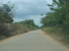
The relief of Sucre State is formed especially by mountainous landscapes, with some valleys not very extensive. The Turimiquire mountain range, to the southwest, shows a rough relief, with steep slopes and heights reaching 2500 meters, while the mountainous system of the Paria Peninsula is characterized by hills of lower elevation. The coast of Sugarcane, essentially towards the west, has all the characteristics of a sinking coast, deep, with large cliffs and scarce beach formation. In contrast, towards the southeast of the entity, in the Gulf of Paria, the land is very flat, with slopes of less than 1% and with insufficient drainage, which has turned it into swampy plains.
Vegetation
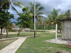
The vegetation of Sucre State is xerophytic in the coastal areas and mountainous in the rural areas located in the Coastal Range, we can also find Caribbean beach plants and trees, such as coconut and cocoa trees. You can also find the oak tree, which has been declared a State tree.
In Paria the vegetation ranges from cloud forest at 1000 meters and annual rainfall calculated between 1000 and 1500 millimeters, to xerophytic as we approach the coast. Its warm and rainy climate is conducive to vegetation, which according to experts is home to species transported by the waters of the Orinoco River from Guyana and native species, which are only found in this area (endemic)."
Demographics
Race and ethnicity
According to the 2011 Census, the racial composition of the population was:
| Racial composition | Population | % |
|---|---|---|
| Mestizo | 54.7 | |
| White | 375,688 | 38.5 |
| Black | 47,815 | 4.9 |
| Other race | 1.9 |
Population centers
The main towns in Sucre State are the following:
- Cumaná: Cumaná is the capital city and seat of the public powers of the state, very famous for its beaches, but it is also important historically for being the birthplace of the great Marshal of Ayacucho, the independence hero Antonio José de Sucre; besides being recognized for its antiquity and multiple historical sites present, as they are: The Castle of San Antonio de la Eminencia, The Castle Santa María de la Cabeza, The Fort Santa Ana, The Metropolitan Cathedral Sacred Eucharistic Heart of Jesus, The Monument, Church co-cathedral of Santa Inés, the Manzanares River, which divides the city into two parts and is one of the oldest treasures that this great population site has, among other great variety of places that make Cumaná the Firstborn of the American Continent, with a great history from the colonial era to our times.
- Carúpano: It was the first port of America with the old continent to have underwater cable which is still maintained in the house of the cable that today is the (Prosperi Foundation), as well as its historical center that is still preserved around the temple Cathedral Santa Rosa de Lima and its majestic tourist carnival of Venezuela. Its rich culture makes it emblematic, and because of its beaches, a resting place for visitors.
- Güiria: It is an important port and tourist place for the population of Sucre, touristically and economically. One of the most important gas reserves in the world was discovered on its coasts.
- Cariaco: This population center is excellent to rest, eat and is also a tourist and economic port.
- Araya: Araya is located in the State of Sucre, in the homonymous peninsula, it is an excellent zone for the tourism, for that reason it is one of the favorite destinations of this state, beaches of white sand and very amiable settlers.
Other towns include Cumanacoa, San Antonio del Golfo, Irapa, Tunapuy, Yaguaraparo, Marigüitar, El Pilar, Río Caribe, San José de Areocuar and Casanay.
Tourism
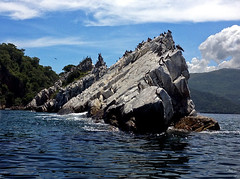
The main tourist areas are the Mochima National Park with varied Caribbean seascapes, large beaches and small islands throughout, several species of birds, fish, molluscs …


Looking for places related to Estado Sucre?
Those are other destinations to find places related to Estado Sucre: