Blue Mountains

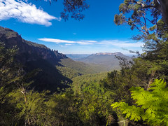
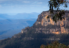
The Blue Mountains are a mountainous region and a mountain range located in New South Wales, Australia. The region is considered to be part of the western outskirts of the Greater Sydney Region, The region borders on Sydney's main metropolitan area, its foothills starting about west of centre of the state capital, close to Penrith on the outskirts of the Greater Metropolitan region. The public's understanding of the extent of the Blue Mountains is varied, as it forms only part of an extensive mountainous area associated with the Great Dividing Range. As defined in 1970, the Blue Mountains region is bounded by the Nepean and Hawkesbury rivers in the east, the Coxs River and Lake Burragorang to the west and south, and the Wolgan and Colo rivers to the north. Geologically, it is situated in the central parts of the Sydney Basin.
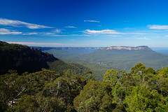
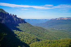
The Blue Mountains Range comprises a range of mountains, plateau escarpments extending off the Great Dividing Range about northwest of Wolgan Gap in a generally southeasterly direction for about , terminating at . For about two-thirds of its length it is traversed by the Great Western Highway, the Main Western railway line and the soon to be completed, Blue Mountains tunnel. Several established towns are situated on its heights, including Katoomba, Blackheath, , and . The range forms the watershed between Coxs River to the south and the Grose and Wolgan rivers to the north. The range contains the Explorer Range and the Bell Range.
The Blue Mountains area includes the local government area of the City of Blue Mountains. Since the early 2010s, the region's biodiversity and infrastructure has been severely affected by massive bushfires of unprecedented size and impact. In 2018 8.4 million people visited the Blue Mountains. The Blue Mountains and Southern Highlands Basalt Forests is a prominent forest community within the ecoregion.
Etymology
Following European settlement of the Sydney area, the area was named the Carmarthen and Lansdowne Hills by Arthur Phillip in 1788. The Carmarthen Hills were in the north of the region and the Lansdowne Hills were in the south. The name Blue Mountains, however, was preferred and is derived from the blue tinge the range takes on when viewed from a distance. The tinge is believed to be caused by Mie scattering which occurs when incoming light with shorter wavelengths is preferentially scattered by particles within the atmosphere imparting a blue-greyish colour to any distant objects, including mountains and clouds. Volatile terpenoids emitted in large quantities by the abundant eucalyptus trees in the Blue Mountains may cause Mie scattering and thus the blue haze for which the mountains were named.
History
Geological history
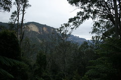
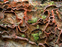
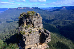
A sandstone plateau dominated by a landscape of endless eucalyptus forests, the Blue Mountains are located at the top of a 470-million-year-old quartzite. In the Permian period, a shallow sea covered the region, when rivers brought shales, siltstones and mudstones. Then during the Mesozoic period, rivers dumped vast amounts of sand, burying the other sedimentary rocks. By about 1 million years ago during the Pliocene era, the Blue Mountains began to form, carving out deep valleys and steep cliffs, with an elevation of 3,900 feet. Its main distinctive natural feature are the Three Sisters, a formation of triple sandstone peaks scoured by erosion, whose rocks are lit by the glimpse of light at the time of day.
Aboriginal inhabitants
The Blue Mountains have been inhabited for millennia by the Gundungurra people, now represented by the Gundungurra Tribal Council Aboriginal Corporation based in Katoomba, and, in the lower Blue Mountains, by the Darug people, now represented by the Darug Tribal Aboriginal Corporation.
The Gundungurra creation story of the Blue Mountains tells that Dreaming creatures Mirigan and Garangatch, half fish and half reptile, fought an epic battle which scarred the landscape into the Jamison Valley.
The Gundungurra Tribal Council is a nonprofit organisation representing the Gundungurra traditional owners, promoting heritage and culture and providing a support for Gundungurra people connecting back to Country.
Gundungurra Tribal Council Aboriginal Corporation has a registered Native Title Claim since 1995 over their traditional lands, which include the Blue Mountains and surrounding areas.
Examples of Aboriginal habitation can be found in many places. In the Red Hands Cave, a rock shelter near Glenbrook, the walls contain hand stencils from adults and children. On the southern side of Queen Elizabeth Drive, at Wentworth Falls, a rocky knoll has a large number of grinding grooves created by rubbing stone implements on the rock to shape and sharpen them. There are also carved images of animal tracks and an occupation cave. The site is known as Kings Tableland Aboriginal Place and dates back 22,000 years.
Australian Colonial History
Arthur Phillip, the first governor of New South Wales, first glimpsed the extent of the Blue Mountains from a ridge at the site of today's Oakhill College, Castle Hill. He named them the Carmarthen Hills, "some forty to sixty miles distant..." and he reckoned that the ground was "most suitable for government stock". This is the location where Gidley King in 1799 established a prison town for political prisoners from Ireland and Scotland.
The first documented use of the name Blue Mountains appears in Captain John Hunter's account of Phillip's 1789 expedition up the Hawkesbury River. Describing the events of about 5 July, Hunter wrote: "We frequently, in some of the reaches which we passed through this day, saw very near us the hills, which we suppose as seen from Port Jackson, and called by the governor the Blue Mountains." During the nineteenth century the name was commonly applied to the portion of the Great Dividing Range from about Goulburn in the south to the Hunter Valley in the north, but in time it came to be associated with a more limited area.
The native Aborigines knew two routes across the mountains: Bilpin Ridge, which is now the location of Bells Line of Road between Richmond and Bell, and the Coxs River, a tributary of the Nepean River. It could be followed upstream to the open plains of the Kanimbla Valley, the type of country that farmers prize.
British settlers initially considered that fertile lands lay beyond the mountains; while in the belief of many convicts China lay beyond. However, there was little fear that the mountains might provide a means of escape since they were considered impassable. This idea was, to some extent, convenient for local authorities. An "insurmountable" barrier would deter convicts from trying to escape in that direction.
A former convict, John Wilson, may have been the first colonist to cross the Blue Mountains. It is also believed that Mathew Everingham, 1795, may have also been partly successful based on letters he wrote at the time which came to light in the late 1980s Wilson arrived with the First Fleet in 1788 and was freed in 1792. He settled in the bush, living with the Aborigines and even functioning as an intermediary between them and the settlers. In 1797 he returned to Sydney, claiming to have explored up to a hundred miles in all directions around Sydney, including across the mountains. His descriptions and observations were generally accurate, and it is possible that he had crossed the mountains via the southern aspect at the Coxs River corridor, guided by the Aborigines.
Governor Hunter was impressed by Wilson's skills and sent him on an expedition with John Price and others in January 1798. The party crossed the Nepean River and moved southwest towards the present site of Mittagong. There they turned west and found a route along the ridge where today the Wombeyan Caves Road is located. In the process they found a way to go west of the mountains, by going around them instead of across them. In March of the same year, Wilson and Price ventured to the Camden area, and then continued further south until they encountered Thirlmere Lakes, finally almost reaching the present site of Goulburn.
It is possible that the accomplishments of this expedition were suppressed by Hunter, who may not have wanted convicts to know that there was a relatively easy way out of Sydney. Wilson was killed by Aborigines after abducting an Aboriginal woman "for his personal use", but he had accomplished much as an explorer. He was never recognised as the first person to cross the mountains, possibly because his Coxs River journey could not be verified, while his route west of Mittagong may have been the "long way around" for a colony that had its eyes fixed on the sandstone fortress west of the Nepean.
Between 1798 and 1813, many people explored various parts of the mountains, from the Bilpin Ridge to the southern regions, today the site of the Kanangra-Boyd National Park. Still, they did not find a definite route across the mountains. The 1813 crossing of the Blue Mountains by Gregory Blaxland, William Lawson and William Charles Wentworth is officially credited as the first successful European crossing. Blaxland set out with Lawson and Wentworth on 11 May 1813 and succeeded in crossing the mountains by 31 May. They ventured as far as to what is now Mount Blaxland, just west of Coxs River.
In November 1813, Macquarie sent the surveyor George Evans on an expedition to confirm the apparent discoveries made by Blaxland and his party. He was also told to see if there existed enough arable land to justify settlement. The issue had become more urgent because the colony was in the grips of a drought.
Evans and his party reached the Fish and Macquarie rivers, and the site of Bathurst. On 7 July 1814, construction of a road across the mountains was begun by William Cox. The work was at the behest of Governor Macquarie. 30 convict labourers and 8 guards completed the road on 14 January 1815 after 27 weeks of hard work.
Since the Blue Mountains are rich in coal and shale, mining for these re…


Looking for places related to Blue Mountains?
Those are other destinations to find places related to Blue Mountains:
- Blue Mountains
- Blue Mountains Nati…
- Grose Valley
- Zig Zag Railway
- Katoomba Scenic Wor…
- Warragamba Dam
- Mount Annan Botanic…
- Jamison Valley
- Lake Burragorang
- Campbelltown Arts C…
- Kowmung
- RAAF Base Richmond
- African Lion Safari
- Camden Airport
- Blue Mountains Gram…
- South Creek
- Coxs
- Caroline Chisholm C…
- Warragamba
- Cambridge Park High…
- Castlereagh Nature …
- Tonalli
- Wollondilly
- Sydney Basin