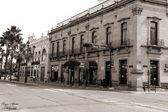
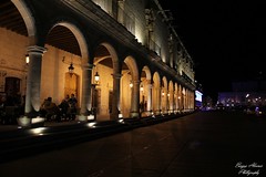
Durango

04172013 455 Mountain Trogon - Trogon mexicanu
Durango (Spanish: [duˈɾaŋɡo]), officially named Estado Libre y Soberano de Durango (English: Free and Sovereign State of Durango; Tepehuán: Korian; Nahuatl: Tepēhuahcān), is one of the 31 states which make up the 32 Federal Entities of Mexico, situated in the northwest of the country. With a population of 1,832,650, the 8th lowest of Mexico's states, Durango has Mexico's second-lowest population density, after Baja California Sur. The capital city, Victoria de Durango, is named after the first President of Mexico, Guadalupe Victoria.
Geography
General information
With , Durango accounts for about 6.3% of the entire territory of Mexico. It is the fourth largest state lying at the extreme northwest of the Central Mexican Plateau, where it meets the Sierra Madre Occidental—the highest peaks in the state. The state has an average elevation of 1,775 meters above sea level, with a mean elevation of 1,750 m in the Valleys region and 2,450 m in the Sierra region. The city of Durango is on the foothills of the Sierra Madre Occidental, with an elevation of 1,857 m.
Durango is landlocked, bordered by Chihuahua, Coahuila, Zacatecas, Nayarit and Sinaloa. It is divided into 39 municipalities, based on the 1917 Constitution of Mexico, and several additional divisions have been made since.
The Sierra Madre Occidental blocks moisture from the Pacific Ocean, impacting the local climate of the state. Las Quebradas region, located over the mountain chain and on the northwest of the state, has a humid subtropical climate. Excepting the highest elevations, the rest of the state has semi-arid and temperate climates. It is hot and dry in the East, with some temperate areas existing at higher elevations.
Most of the state is mountainous and heavily forested, with the Sierra Madre Occidental covering around two-thirds of the state. Like much of northern Mexico, the state has worked to reforest the degraded forests of the Sierra Madre Occidental and Sierra Madre Oriental. Reforesting efforts have focused on replanting native tree species, versus those used for wood production. However, the tree density in many areas is still too low, especially on the eastern slopes of the Sierra Madre Occidental where tree poaching and clearing for agricultural activities is problematic.
Many rivers begin in Durango, but lead into other Mexican states. Some of these rivers empty into the Pacific, or into the lake area of La Comarca, while one, the Florida, flows into the Gulf of Mexico.
Ecological regions
Ecologically, the state is divided into four regions: La Quebrada, the Sierra, the Valleys and the Semi-desert.
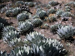
The Semi-desert (sometimes called the Bolsón de Mapimí) is located in the northeast of the state and includes the municipalities of Hidalgo, Mapimí (including the Silent Zone, Tlahualilo, San Pedro del Gallo, San Luis del Cordero, Nazas, Lerdo, Gómez Palacio, Cuencamé, Santa Clara, General Simón Bolívar and San Juan de Guadalupe. Most of the terrain here is flat and its climate is dry. Temperatures are cold in the winter and hot in the summer. These municipalities are classified as either part of the Chihuahua Desert or in the transition zone. The area is relatively flat with some mountain ranges and a slight incline towards the interior of the country. The area was at one time under the sea, but today the vegetation consists of scrub, nopal cactus, maguey plants, barrel cactus and other arid zone plants. It is defined by two rivers: the Nazas and the Aguanaval. The region has two reservoirs: the (Palmito) and the (Tórtolas), located between the Cuencamé and Lerdo municipalities. Animals that can be found here include coyotes, gavilanes (sparrowhawks), various snakes, owls, chameleons, tarantulas and scorpions. Most of the economically important natural resources come from mining, including deposits of gold, silver, iron and mercury. There are also large deposits of marble.
The La Laguna is short for La Comarca de la Laguna (the region of the lake) or Comarca Lagunera (region of lakes), an arid and semi-arid region that covers a significant portion of northeastern Durango and southeastern Coahuila. The area was created by sediments from torrential river flows deposited over large valleys. These river flows also created lagoons which served to recharge underground aquifers or remain as intermittent surface waters. Originally, the rivers supported habitat for native grasses, rush and ditch reed which provided habitat for various water birds and fish.
The area is home to Durango's only caverns. The Rosario Caves (grutas) are located near Ciudad Lerdo, as well as the Mapimí Biosphere, noted for various plants and the desert tortoise. It is a highly protected area centering on where the states of Chihuahua, Coahuila and Durango meet.
The Valleys are located in the center of the state and include the municipalities of Nombre de Dios, Durango, Nuevo Ideal, Canatlán, Guadalupe Victoria, Pánuco de Coronado, Poanas, Súchil, Vicente Guerrero, Ocampo, San Bernardo, Indé, Coneto de Comonfort, El Oro, Rodeo, San Juan del Río and Peñón Blanco. The region consists principally of river valleys and plains located among small mountain ranges. The main peaks in this area include the San Jacinto in the Silla Mountains and Peñon Blanco, which many schoolchildren in the area take trips to. Other major geographical formations in the Valleys Region include cliffs called Las Catedrales, along with those called Malpaís and La Breña, which were formed by lava flows over 250,000 hectares. The area is also home to the Cerro de Mercado which is important for its large deposit of iron.
The valleys proper are flat and suitable for farming, with irrigation from the Nazas, Florido and Tunal Rivers. Reservoirs for this purpose include the Santiaguillo, Guatimapé and Refugio Salcido. It has large areas with grass, , and poplar trees. There is a shallow wetland area called the Guatimapé, or Santiguillo. It provides vital habitat for flocks of migrating birds in winter, especially cranes, geese and ducks. Around this lake, there are Mennonite communities who are noted for their cheeses and cured meats. The region also provides habitat for coyotes, rabbits, squirrels, foxes, geese and ducks. The rivers contain fish such as catfish, bass, carp and tilapia. The area also has hot springs due to tectonic activity. The best known springs are the Zape, Atotonilco and the Hervideros. The area is home to the state capital of Durango and many former haciendas that attest to the area's agricultural history.
The Sierra region is in the west of the state. It includes the municipalities of Guanaceví, Tepehuanes, and parts of Santiago Papasquiaro, Topia, Canelas, Otáez, Tamazula, San Dimas, Pueblo Nuevo, Mezquital, Durango, Ocampo and San Bernardo. The terrain is rugged with freezing temperatures in the winter and snow in the higher elevations. There is also a rainy season in the summer. The vegetation in the Sierra region is mostly pine–oak forest, consisting of pines, oak, cedar, and strawberry trees as well as grasslands. The fauna includes deer, pumas, coyotes, foxes, badgers and wild turkeys. Fish such as bass and catfish are found in the rivers, along with various species of birds and reptiles. Most of the state's rivers originate in the mountains of this region.
Las Quebradas is found in the far west of the state, including parts of Mezquital, Pueblo Nuevo, San Dimas, Otáez, Santiago Papasquiaro, Tamazula, Topia, Canelas and Tepehuanes. The region is subdivided by the rugged, western flank of the Sierra Madre. The terrain features deep ravines, canyons and fast-flowing rivers. The Humaya, Tamazula, Los Remedios, Piaxtla, Presidio, and Baluarte rivers flow west to the Pacific through the state of Sinaloa. Further south, the Acaponeta, San Pedro Mezquital, and Huaynamota rivers flow southwest through the state of Nayarit. The region, especially its ravines and canyons, is hot and humid. It receives the most rainfall in the state. There is greater diversity of flora and fauna in its rainforests compared to the desert regions of the state. Animal species include pumas, white-tailed deer, armadillos, badgers, iguanas and a large number of bird species. At higher elevations, between 600 and 1200 meters, the vegetation changes to pine forests and the climate is more temperate. This area has had the most human habitation and agriculture.
When the Jesuits arrived to the Quebradas, they introduced the grazing of cattle and large-scale farming of corn, sugar cane and fruit trees. In the hotter and wetter areas, they introduced bananas, cherimoyas, guavas, zapotes, plums, avocados, oranges and other types of citrus. However, the difficulty of crossing the mountains to the more prosperous Valleys region limited the economy here.
Las Quebradas has mineral deposits, principally silver with some gold. Most of these deposits are found in an area that extends from the Humaya River to San Diego. During the 18th century, a number of royal mines were in operation here. They have been worked intermittently since them, with the last major activity in the late 19th and early 20th century. The deposits attracted Europeans, displacing the native Acaxes, Xiximes and other indigenous groups, whose numbers fell with the introduction of European diseases. Many of the towns in this area including Félix de Tamazula, Valle de Topia, Santa Veracruz de Topia, Nuestra Señora de la Asunción de Siánori, Santa María de Otáez and San José de Canelas began as mining towns.
The mountains over 3,000 meters above sea level are dominated by dramatic landscapes, including waterfalls, old-growth pine forests and ravines, such as the Basís Quebrada on the Presidio River. The sinkholes and rock formations, such as the El Espinazo del Diablo, are visible from the old highway to Mazatlan. It is one of the most representative landscapes of northwest Mexico. Cerro Gordo is the highest point in the state and is considered sacred to both the Te…


Looking for places related to Durango?
Those are other destinations to find places related to Durango: