Lauterbrunnen

Sunrise over the Lauterbrunnen Valley
Lauterbrunnen is a village and municipality in the Interlaken-Oberhasli administrative district in the canton of Bern in Switzerland. The municipality comprises the other villages of Wengen, Mürren, Gimmelwald, Stechelberg, and Isenfluh, as well as several other hamlets. The population of the village of Lauterbrunnen is less than that of Wengen, but larger than that of the others.
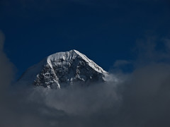
The municipality comprises the Lauterbrunnen Valley (German: Lauterbrunnental), located at the foot of the Bernese Alps. It is notably overlooked by the Eiger, Mönch, and Jungfrau and many other high peaks. The valley, drained by the White Lütschine, comprehends the Soustal, the Sefinental and the upper Lauterbrunnen Valley with Untersteinberg. The valley includes several glaciers. Together with the adjacent valley of Grindelwald, the Lauterbrunnen Valley forms part of the Jungfrau Region of the Bernese Oberland, between Interlaken and the main crest of the Bernese Alps.
Similarly to Grindelwald, Lauterbrunnen has become a major tourist destination and is connected to Interlaken by the Bernese Oberland Railway and is the start of the Wengernalp Railway, leading to Kleine Scheidegg. The latter resort is the start of the Jungfrau Railway, the highest railway in Europe and a gateway to the Jungfrau-Aletsch protected area.
Toponymy
Lauterbrunnen was first mentioned in 1240 as "in claro fonte", a Romance language place name meaning "clear spring". By 1253, it was known to German speakers as Liuterbrunnon; the town had an alternate spelling of Luterbrunnen by 1268. While the meaning of brunnen is undoubtedly spring or fountain, there is some dispute about the meaning of lauter. Some translate it as clear, clean or bright (which compares to the earlier Romance language meaning of the place mentioned above), while others translate it as "many" or "louder". A local explanation is that the name Lauterbrunnen means "many springs", using a modern meaning of the word lauter in German; however, this could be an example of a folk etymology.
History
Lauterbrunnen is first mentioned in 1240 as in claro fonte. In 1304 it was mentioned as Luterbrunnen.
The oldest trace of a settlement in the area is a single Roman coin which was discovered in the Blumental.
When the Lauterbrunnen Valley first appears in the historic record, during the 13th century, it was owned by the Freiherr of Wädenswil. In 1240 the Freiherr of Wädenswil sold the Sefinen Valley to Interlaken Monastery. Over the following century, the Monastery and other local lords began to expand their power in the Lauterbrunnen and neighboring valleys. However, around 1300, the Lord of Turn began to settle his Walser speaking people in the nearby Lötschen Valley and into the highlands of the Lauterbrunnen Valley. By 1346, the Walser villages of Lauterbrunnen, Gimmelwald, Mürren, Sichellauenen and Trachsellauenen all had village governments and a certain amount of independence from the Monastery. Three years later, much of the Bernese Oberland unsuccessfully rose up against Monastery. When the Monastery suppressed the rebellion, the Walser villages bore the brunt of the Monastery's wrath.
By the 15th century, the villages of the valley were part of the large parish of Gsteig bei Interlaken (now part of Gsteigwiler). Between 1487 and 1488, the villagers in Lauterbrunnen built a filial church of the parish. In 1506, the parish appointed a full-time priest for Lauterbrunnen. In 1528, the city of Bern adopted the new faith of the Protestant Reformation and began imposing it on the Bernese Oberland. Lauterbrunnen joined many other villages and the Monastery in an unsuccessful rebellion against the new faith. After Bern imposed its will on the Oberland, they secularized the Monastery and annexed all the Monastery lands. Lauterbrunnen became the center of a new Reformed parish.
Mines were built in the Trachsellauenen area in the upper valley beginning in the late 16th century. An iron smelter was built in Zweilütschinen (now part of Gündlischwand) in 1715 to process the iron ore from Trachsellauenen. However most of the money from the mines went to the noble landowners. The villagers remained very poor. In the 17th and 18th centuries the poverty was so widespread that many of the villagers joined mercenary regiments or emigrated. A majority of the emigrants moved to the Carolinas in the United States. Beginning in the late 18th century, foreign mountain climbers began to use Lauterbrunnen as a starting point for their expeditions into the nearby Alps. Initially the climbers stayed in the village rectory. However, as Lauterbrunnen's fame grew and with the completion of a road from Interlaken in 1834 and the 1890 Bernese Oberland Railway, more hotels were needed for tourists. As new hotels were built, other tourist infrastructure was also built in the village. They built cable cars to Mürren in 1891 and to Wengen in 1893. But the most significant piece of infrastructure was the Jungfrau railway which was built in 1912. The Jungfrau rack railway runs from Kleine Scheidegg to the highest railway station in Europe at Jungfraujoch. The railway runs almost entirely within a tunnel built into the Eiger and Mönch mountains and contains two stations in the middle of the tunnel, where passengers can disembark to observe the neighboring mountains through windows built into the mountainside. In 1909 the English brothers Walter and Arnold Lunn popularized skiing, curling and bobsledding at Lauterbrunnen. These winter sports provided a whole new group of winter tourists and converted the summer tourist industry into a year-round business. The tourist economy of Lauterbrunnen was devastated due to World War I and II and the Great Depression. However, following the end of World War II, tourism rebounded. Many new vacation homes and chalets were built along with ski lifts, chair lifts and a heliport.
On 1 January 1973 the former municipality of Isenfluh merged into the municipality of Lauterbrunnen. On 31 December 2009 Amtsbezirk Interlaken, the municipality's former district, was dissolved. On the following day, 1 January 2010, it joined the newly created Verwaltungskreis Interlaken-Oberhasli.
Geography
Lauterbrunnen lies at the bottom of a U-shaped valley that extends south and then south-westwards from the village to meet the Lauterbrunnen Wall. The Lauterbrunnen Valley (Lauterbrunnental) is one of the deepest in the Alpine chain when compared with the height of the mountains that rise directly on either side. It is a true cleft, rarely more than one kilometer in width, between limestone precipices, sometimes quite perpendicular, everywhere of extreme steepness. In places the cliff walls are up to high. It is to this form of the valley that it owes the numerous waterfalls from which it derives its name. The streams descending from the adjoining mountains, on reaching the verge of the rocky walls of the valley, form cascades so high that they are almost lost in spray before they reach the level of the valley. The most famous of these is Staubbach Fall, less than one kilometer from the village of Lauterbrunnen. The high Staubbach is the highest free falling waterfall in Switzerland. Also near Lauterbrunnen is the highest waterfall in Switzerland, the Mürrenbach Fall. Finally, the Mattenbachfall (cascade waterfall) with a height of 930 meters is Europe's highest waterfall and the third highest in the world.
Weisse Lütschine river flows through Lauterbrunnen and overflows its banks about once a year. The source of the river comes from melting snow high in the mountains, thus making it a very pure and clean source of water. It is common practice in camp sites to chill drinks in the water. Trümmelbach Falls is from Lauterbrunnen, connected by bus from the station.
Most famous waterfalls in Lauterbrunnen:
- Staubbach Fall
- Trimmelbach Falls
- Mirrenbach Fall
- Spissbach Falls
- Sefinen Fall
- Staldenbach Falls
- Holdri Falls
- Talbach Fall
The valley also includes many glaciers, such as the Tschingelfirn and the Rottalgletscher.
The municipality of Lauterbrunnen extends a considerable distance beyond the village and valley, with an area of . It reaches as far as the peaks of the Eiger, Mönch and Jungfrau to the east, the Gletscherhorn, Mittaghorn, Grosshorn, Breithorn and Tschingelhorn to the south, and the Gspaltenhorn and Schilthorn to the west. The Kleine Scheidegg Pass crosses over to Grindelwald to the east, whilst the Sefinenfurgge Pass crosses to Griesalp and Reichenbach im Kandertal to the west. Both passes carry hiking trails that form part of the Alpine Pass Route, a long-distance hiking trail across Switzerland between Sargans and Montreux. Besides the village of Lauterbrunnen, the municipality also includes the villages of Wengen, Mürren, Gimmelwald, Stechelberg, and Isenfluh.
Of the municipal area, or 22.4% is used for agricultural purposes, while or 17.5% is forested. Of the rest of the land, or 1.4% is settled (buildings or roads), or 0.7% is either rivers or lakes and or 58.0% is unproductive land. Of the built-up area, housing and buildings make up 0.7% and transportation infrastructure make up 0.5%. Of the forested land, 13.6% of the total land area is heavily forested and 2.0% is covered with orchards or small clusters of trees. Of the agricultural land, 3.5% is pastures and 18.9% is used for alpine pastures. All the water in the municipality is flowing water. Of the unproductive areas, 10.3% is unproductive vegetation, 31.3% is too rocky for vegetation and 16.3% of the land is covered by glaciers.
Coat of arms
The blazon of the municipal coat of arms is Per fess Argent a Semi Ibex rampant couped Sable and Vert three Piles wavy issuant from base of the first. The three stripes represent three famous waterfalls around the village.
Demographics
The village Lauterbrunnen has a population of . , 22.6% of the population are resident foreign nationals. Over the last 10 years (2000-2010) the population has changed at a rate of -8.9%. Migration…


Looking for places related to Lauterbrunnen?
Those are other destinations to find places related to Lauterbrunnen: