Sognefjord
Sognefjorden village
The Sognefjord or Sognefjorden (Norwegian: [ˈsɔ̂ŋnəˌfjuːɳ], English: Sogn Fjord), nicknamed the King of the Fjords (Norwegian: Fjordenes konge), is the largest and deepest fjord in Norway. Located in Vestland county in Western Norway, it stretches inland from the ocean to the small village of Skjolden in the municipality of Luster.
The fjord gives its name to the surrounding district of Sogn. The name is related to Norwegian word súg- "to suck", presumably from the surge or suction of the tidal currents at the mouth of the fjord.
Geography
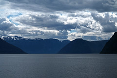
The fjord runs through many municipalities: Solund, Gulen, Hyllestad, Høyanger, Vik, Sogndal, Lærdal, Aurland, Årdal, and Luster. The fjord reaches a maximum depth of below sea level, and the greatest depths are found in the central parts of the fjord near Høyanger. Sognefjord is more than deep for about of its length, from Rutledal to Hermansverk. Near its mouth, the bottom rises abruptly to a sill about below sea level. The seabed in Sognefjord is covered by some sediments such that the bedrock is some below sea level. The fjord is up to wide. The average width of the main branch of the Sognefjord is less than . The depth increases gradually from Årdal to a central basin reaching more than in depth located between Leikanger and Brekke. From Brekke the floor rises rapidly to Losna island, then drops gradually with a threshold at about in the Solund area. Thresholds occur in an area with sounds, valleys, and low land where the glacier was allowed spread out and lose its erosive effect.
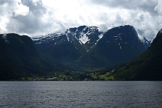
Cliffs surrounding the fjord rise almost sheer from the water to heights of and more. Around the outer area the land rises to about above the sea, while in the inner areas of the fjord, they reach about . The inner part has extensive tributary fjords such as Aurlandsfjorden, while the outer part is connected by narrow sounds to neighbouring fjords. Near the coast the fjord mouth is bounded largely by low islands and skerries that are part of the strandflat.
The inner end of the Sognefjord is southeast of a mountain range rising to about above sea level and covered by the Jostedalsbreen, continental Europe's largest glacier. Thus the climate of the inner end of Sognefjorden and its branches are not as wet as on the outer coastline. Hurrungane range at the eastern end of the fjord reaches . The greatest elevation from seabed to summit is at Sogndal. Several rivers pour fresh water into the fjord with an annual "spring" flood in June. The mouth of the fjord is surrounded by many islands including Sula, Losna, and Hiserøyna. The Sognefjord cuts through a northwestern gneiss area with a south-west to north-east structure, and penetrates the Caledonian fold through in the inner part. There is no clear relation between the east–west direction of the main fjord and the fold patterns of the bedrock, while some of tributary fjords in the parts corresponds to fold pattern.
The volume of the whole Sognefjorden including its various branches is about , while the total volume of rock eroded by glaciers from the entire Sognefjord system and adjacent valleys is about .
Branches
There are many smaller fjords which branch off the main fjord.
- Sognesjøen (mouth),
- Lifjorden,
- Høyangsfjord,
- Arnafjord,
- Esefjord,
- Fjærlandsfjord,
- Sogndalsfjord,
- Aurlandsfjord,
- Nærøyfjord (a World Heritage Site),
- Lærdalsfjord,
- Årdalsfjord,
- Lustrafjord (innermost),
Lustrafjorden
The innermost arm of the Sognefjorden is called the Lustrafjord, in the municipality of Luster. At its end is the village of Skjolden, which is an access point to Jotunheimen National Park. In earlier times, transport between Bergen and the Scandinavian inland was by boat between Bergen and Skjolden and from there on a simple road over the highlands (today Norwegian County Road 55), or by boat to Lærdal and through the mountain pass to Valdres (now European route E16).
Origin and geology
The valley of Sognefjord is one of various valleys of western Norway that certainly predates the Quaternary glaciations. It existed already as part of the ancient Paleic surface but had at the time much gentler slopes. The fjords of western Norway formed in connection to the east-ward tilting of much of Norway during the Cenozoic uplift of the Scandinavian Mountains. This uplift, that occurred long before the Quaternary glaciations, enabled rivers to incise deeply the Paleic relief. An estimate of 7610 km3 of rock has been eroded from the Sognefjord drainage basin since the Paleic surface formed. The fluvial and glacial erosion that made the fjords has followed structural weaknesses in the crust.
During the last glaciation the ice reached a maximum thickness of nearly 3000 meters in the Sognefjord area. Confluence of tributary fjords led excavation of the deepest fjord basin. Until about 30 km from the very coast the Sognefjord glacier was apparently constricted to its narrow channel of homogeneous gneiss, then the glacier suddenly spread out presumably through sounds and low valleys.
Tourism
Boats connect settlements along the fjord and its sidearms. Larger villages on the fjord and its branches include Leirvik, Ytre Oppedal, Vadheim, Høyanger, Vikøyri, Balestrand, Hermansverk, Sogndalsfjøra, Gudvangen, Flåm, Aurlandsvangen, Lærdalsøyri, Årdalstangen, Gaupne and Solvorn. Gudvangen is situated by the Nærøyfjord, a branch of the Sognefjord particularly noted for its unspoiled nature and dramatic scenery, and only across at its narrowest point. Together with the Geirangerfjord in Møre og Romsdal, the Nærøyfjord is a UNESCO World Heritage Site. From the village of Flåm, the Flåm Railway climbs up to Myrdal Station in a distance of only —the steepest unassisted railway climb in the world.
Around the inner end of the fjord, three of Norway's famous stave churches have survived: Kaupanger and Urnes (along the shoreline) and Borgund (into the Lærdal valley).
The Sognefjord Span (power lines) crosses the fjord with a span of . This is the second largest span of power lines in the world. The fjord has become a tourist attraction with summer tourists being an important part of the local economy.
Other
- On 24 November 1972, the submarine KNM Sklinna of the Royal Norwegian Navy had "contact" with what they presumed was a Russian Whiskey-class submarine after a 14-day pursuit in the Sognefjorden. Military documents released later confirm this episode.
External links
- www.sognefjord.no
- Flåmsbana information
- Art of the States: Bright Days of Little Sunlight musical work inspired by the Sognefjord
- Google Earth view of the Sognefjord
Places Sognefjord

Hotels Sognefjord
 Holiday Home Solsvika - FJS125 by InterhomeLeirvik
 Holiday Home Sognesjön - FJS128 by InterhomeBø
 Holiday Home Nesjevik - FJS124 by InterhomeLeirvik
 Holiday Home Nesholmen - FJS127 by InterhomeLeirvik
 Holiday Home Blåsenberg - FJS126 by InterhomeLeirvik
 Holiday Home Nanna - FJS130 by InterhomeFolkestad
 Two-Bedroom Holiday home in BrekkeDingja
 Holiday Home Idun - FJS131 by InterhomeFolkestad
Looking for places related to Sognefjord?
Those are other destinations to find places related to Sognefjord: