Tartus Governorate

090102_Siria_121242C
Tartus Governorate, also transliterated as Tartous Governorate, (Arabic: مُحافظة طرطوس / ALA-LC: Muḥāfaẓat Ṭarṭūs) is one of the 14 governorates of Syria. It is situated in western Syria, bordering Latakia Governorate to the north, Homs and Hama Governorates to the east, Lebanon to the south, and the Mediterranean Sea to the west. It is one of the few governorates in Syria that has an Alawite majority. Sources list the area as 1,890 km² or 1,892 km², with its capital being Tartus.
History
The governorate was historically part of the Alawite State, which existed from 1920–1936.
It was formerly part of Latakia governorate, but was split off circa 1972.
The region has been relatively peaceful during the Syrian civil war, being a generally pro-Assad region that had remained under government control. However in 2013 massacres against Sunni Muslims occurred in Bayda and Baniyas, and a suicide bombing claimed by Islamic State occurred in Tartus in May 2016. Tartus is home to a major Russian naval base.
Archeological sites
- Al-Kahf Castle – Isma'ili castle
- Aleika Castle – Isma'ili castle
- Amrit – Phoenician city
- Chastel Rouge (Qal’at Yahmur) – Crusader castle
- Hosn Suleiman
- Margat – Crusader castle
- Tell Kazel – Bronze age site (possibly the ancient city of Sumur)
Geography
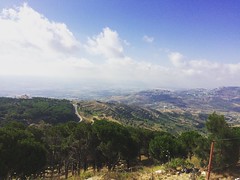
Tartus comprises roughly half of Syria's Mediterranean coastline; offshore lie five small islands, the largest of which is Arwad. Inland the terrain is mountainous, comprising a section of the Syrian Coastal Mountain Range (Nusayriyah Mountains). The Nahr al-Kabir river forms the border with Lebanon to the south.
Settlements
Tartus is the regional capital; other major settlements include Al-Hamidiyah, Al Qadmus, Al-Sawda, Ayn ash Shams, Baniyas, Qusaybah and Safita.
Districts
The governorate is divided into five districts (manatiq). The districts are further divided into 27 sub-districts (nawahi):
- Tartus District (7 sub-districts)
- Tartus Subdistrict
- Arwad Subdistrict
- Al-Hamidiyah Subdistrict
- Khirbet al-Maazah Subdistrict
- Al-Sawda Subdistrict
- Al-Karimah Subdistrict
- Al-Safsafah Subdistrict
- Baniyas District (7 sub-districts)
- Baniyas Subdistrict
- Al-Rawda Subdistrict
- Al-Annazah Subdistrict
- Al-Qadmus Subdistrict
- Hammam Wasel Subdistrict
- Al-Tawahin Subdistrict
- Talin Subdistrict
- Duraykish District (4 sub-districts)
- Duraykish Subdistrict
- Junaynet Ruslan Subdistrict
- Hamin Subdistrict
- Dweir Ruslan Subdistrict
- Safita District (6 sub-districts)
- Safita Subdistrict
- Mashta al-Helu Subdistrict
- Al-Bariqiyah Subdistrict
- Sebei Subdistrict
- Al-Sisiniyah Subdistrict
- Ras al-Khashufah Subdistrict
- Al-Shaykh Badr District (3 sub-districts)
- Al-Shaykh Badr Subdistrict
- Brummanet al-Mashayekh Subdistrict
- Al-Qamsiyah Subdistrict
Demographics
As per the 2004 Syrian census the population was 701,400. A 2011 UNOCHA estimate put the population at 797,000, though this has likely changed since the start of the war.
The majority at 72% are Alawites, 7% Sunni Muslim, 8% Ismaili, and 13% Christian. There is a small Cretan Greek community concentrated in Al-Hamidiyah, the descendants of refugees who fled the Greco-Turkish War of 1897.
External links
- etartus The First Complete website for Tartus news and services