Upper Lusatia
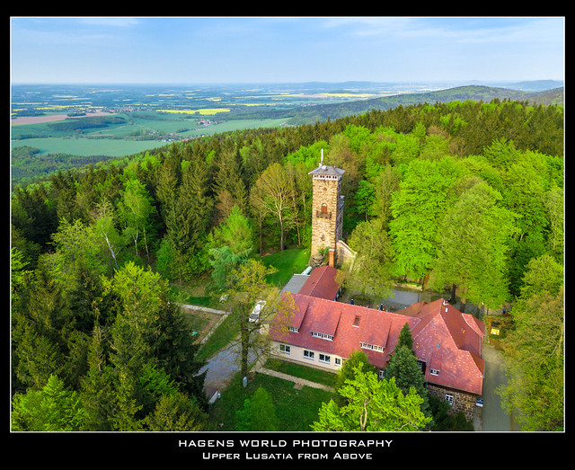
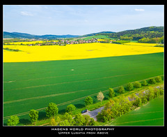
Upper Lusatia from Above
Upper Lusatia (German: Oberlausitz German: [ˈoːbɐˌlaʊzɪts]; ; ; ; Polish: Łużyce Górne or Milsko;) is a historical region in Germany and Poland. Along with Lower Lusatia to the north, it makes up the region of Lusatia, named after the Slavic Lusici tribe. Both parts of Lusatia are home to the West Slavic minority group of the Sorbs.
The major part of Upper Lusatia is part of the German federal state of Saxony, roughly comprising Bautzen district and Görlitz district. The northwestern extremity, around Ruhland and Tettau, is incorporated into the Oberspreewald-Lausitz district of the state of Brandenburg. The eastern part of Upper Lusatia is in Poland, east of the Neisse (''Nysa'') river, in Lower Silesian Voivodeship. A small strip of land in the north around Łęknica is incorporated into Lubusz Voivodeship, along with the Polish part of Lower Lusatia.
The historic capital of Upper Lusatia is Bautzen/Budyšin, while the largest city in the region is Görlitz/Zgorzelec, halved between Germany and Poland since 1945. The name Lusatia superior was first recorded in a 1474 deed, derived from the adjacent Lower Lusatian lands in the north, which originally were just called the March of Lusatia. The Upper Lusatian territory was previously referred to as Milsko in contemporary chronicles, named after the local West Slavic Milceni tribe, later also called Land Budissin.
Geography and nature
Geomorphological Upper Lusatia is shaped by the uniform Lusatian granite massif, only the north and northeast, the plain of the Upper Lusatian Heath and Pond Landscape is Pleistocene formed. The UNESCO has declared this area a Biosphere Reserve in 1996, in particular for the protection of otters. The middle part is hilly, while the south is characterized by the Lusatian Mountains, the westernmost range of the Sudetes.
Mountains and rivers
The highest elevations of the German part of Upper Lusatia are in the Zittau Mountains (Lusatian Ridge), part of the Lusatian Mountains forming the border with the adjacent Bohemian region in the south, which today belong to the Czech Republic. The highest peaks of the Zittau Mountains are the Lausche at and Hochwald at . The adjacent Lusatian Highlands comprise the Landeskrone (420 m), Löbauer Berg (448 m), Kottmar (583 m), Czorneboh (561 m), Bieleboh (499 m), and Valtenberg (587 m). However, the highest point of historic Upper Lusatia is the Tafelstein (Tabulový Kámen) in the Polish part, located at on the eastern slopes of the Smrk (Tafelfichte) in the Jizera Mountains (Isergebirge), the border tripoint of Upper Lusatia with the historical region of Lower Silesia to the east and Bohemia to the south.
All major rivers in the Upper Lusatia flow from south to north. In the west, the Pulsnitz at Königsbrück (the "Gate to Upper Lusatia" on the Via Regia trade route) formerly marked the border with the Meissen lands of the Saxon Electorate. The Spree river has its source in the Lusatian Highlands in the far south of the country and flows through Bautzen. The Lusatian Neisse has formed the German-Polish border since 1945. The river rises in the Czech Jizera Mountains, enters Upper Lusatia near Zittau, flows through Görlitz/Zgorzelec and leaves the country at Bad Muskau for Lower Lusatia. Most of the smaller rivers are called -wasser (water), often in combination with the name of a village which the stream flows through. The eastern border of Upper Lusatia with Lower Silesia is marked by the River Kwisa, who flows past Lubań (Lauban) and continues north towards the Silesian lands into the Bóbr river.
The central hilly Gefilde (Pahórčina) landscape between Kamenz and Löbau was especially well suited for agriculture and is still very profitable. In the 19th century, in the northern part of Upper Lusatia, in the east on both sides of the Neisse river and around Hoyerswerda large quantities of brown coal were found. Especially the digging in open pits has destroyed large parts of the old cultural landscape. Currently the Nochten pit south of Weißwasser and Turów near Bogatynia in the Polish part are still active. Many of the old coal mines have been restored since the 1970s, especially after 1990, when particular attention was paid to revitalize the landscape. The newly formed lakes are already named and advertised as the Lusatian Lake District (Lausitzer Seenland).
Natural regions
Today, Upper Lusatia is grouped into eight natural regions or landscapes:
- The Zittau Mountains (southeastern tip of Upper Lusatia)
- The East Lusatian Hill Country and River Neisse region (on the Neisse from Görlitz to Zittau, north of the Zittau Mountains)
- The Lusatian Highlands (southern Upper Lusatia to Bohemia)
- The Northwest Lusatian Highlands (northwest from Bischofswerda to Kamenz)
- The Upper Lusatian Gefilde region (around Bautzen and Löbau north of the Highlands)
- The Upper Lusatian Heath and Lake District (east of Kamenz to Niesky)
- The Königsbrück-Ruhland Heaths in the northwest (northwest of Kamenz, west of Hoyerswerda)
- The Muskau Heath in the northeast (around Bad Muskau and Weisswasser, Poland, in the east)
History
The hunters of the Middle Stone Age (until about 8000 BC) only crossed through the area. Even the oldest agricultural cultures (4500 BC to 3300 BC) left behind only little evidence of settlement. In the early Bronze Age (11th century BC to 9th century BC) people of the Lusatian culture entered the previously uninhabited region from Bohemia and the Lusatian Neisse. Archeological evidence documents a path between the settlement areas around Bautzen/Budyšin and Zittau/Žitawa. A fortified hill from the 10th century BC, the Schafsberg near Löbau/Lubij played a special role. Another significant settlement was on the cliff above the Spree river, where in the course of history Bautzens Ortenburg was built, dominant and administrative center of what would become Upper Lusatia.
Slavs settled in the region from the 7th century. In the area between today's cities of Kamenz/Kamjenc and Löbau the tribe of the Milceni was located. Their center was a fortified town at the site of today's Ortenburg in Bautzen. Another early Slavic settlement was situated in the valley of the Neisse river. The rural Sorbian population erected numerous hill forts, which were tribal centers as well as the residences of Slavic nobility.
Meissen
The independent development of the West Slavic tribes was interrupted in the 10th century by the expansion of the German state of East Francia. With the raids of 921/922 and 928/929 King Henry the Fowler initiated a period of military subjugation of the Polabian Slavs. In 932 the Milceni were forced to pay tribute. After Henry's death in 936 the Milceni once again became independent, but were subdued again in 939 by King Otto I of Germany. As a result, the Milceni lands, despite persistent militant struggles, became part of the vast Marca Geronis under the Saxon margrave Gero and after 965 of the newly established Margraviate of Meissen.
All the major wall ring castles in the border areas were strengthened and prepared as starting points for further conquests. In place of the Milceni castles, German Burgwards appeared (first mentioned 1006), such as the Ortenburg Castle in Bautzen, or the castles of Göda/Hodźij and Doberschau/Dobruša. In the year 1002 the city of Bautzen was first mentioned by the chronicler Thietmar of Merseburg. Until the second half of the 10th century the fights continued, and in 990 the Milceni were finally subdued by Margrave Eckard I of Meissen. The church of Upper Lusatia was assigned to the Diocese of Meissen in 968. In 1007, the diocese received the first donation in Milceni lands, the castles Ostrusna (probably Ostritz) and Godobi (Göda).
Soon, however, the German feudal rule was threatened by the ascending Kingdom of Poland and its western expansion. In 1002 Bolesław I Chrobry conquered both Upper and Lower Lusatia and forced German king Henry II to enfeoff him with the Gau Milsca. After several volatile and bitter feuds both parties signed the Peace of Bautzen on 30 January 1018, which assigned the Milceni lands of Upper Lusatia and Lusatia proper (today Lower Lusatia) to Poland. After the victory of Emperor Conrad II over the Polish king Mieszko II Lambert in 1031, Upper Lusatia again came under the rule of the Meissen margraves, confirmed by the 1033 Treaty of Merseburg.
During the Investiture Controversy in 1076, King Henry IV of Germany granted Budissin Land to Duke Vratislaus II of Bohemia as an Imperial fief in turn for his support in the Saxon Rebellion. The son-in-law of Vratislaus, Count Wiprecht of Groitzsch, ruled it independently from 1084 to 1108 residing at Ortenburg Castle. In 1091, a further donation to the church was made, when Henry IV transferred five other villages in the Milzenerland, four of them south of Göda. For 1144 it is documented that the Zagost province, an area southeast of Görlitz around Zawidów (Seidenberg), was a part of Budissin Land. Also in this region, the Diocese of Meissen was equipped with possessions. Upper Lusatia reached the Kwisa (Queis), the border to Silesia and its largest expansion to the east, already in the 12th century.
Bohemia
In 1156 Emperor Frederick Barbarossa signed an alliance with the Přemyslid duke Vladislaus II of Bohemia. He not only promised him the royal crown but also the investiture with Ortenburg Castle and Land Budissin, which both became reality two years later. Therewith the first Bohemian period in the history of Upper Lusatia, with far-reaching consequences for the development of the country, began.
In the first century of Přemyslid rule all major towns of Upper Lusatia, and all major religious institutions of the country – apart from the older Bautzen – were established. The Meissen bishop Bruno II from 1213 to 1218 established the college of St. Peter in Bautzen, which was richly endowed by King Ottokar I of Bohemia and his successors; Queen Kunigunde in 1234 donated the Cistercian monastery of St. Marienthal, which was subjected to …
Places Upper Lusatia


Looking for places related to Upper Lusatia?
Those are other destinations to find places related to Upper Lusatia: