Zacatecas
Zacatecas (Spanish: [sakaˈtekas]), officially the Free and Sovereign State of Zacatecas (Spanish: Estado Libre y Soberano de Zacatecas), is one of the 31 states of Mexico. It is divided into 58 municipalities and its capital city is Zacatecas.
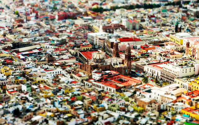
Zacatecas is located in North-Central Mexico. It is bordered by the states of Durango to the northwest, Coahuila to the north, Nayarit to the west, San Luis Potosí and Nuevo León to the east, and Jalisco, Guanajuato and Aguascalientes to the south. The state is best known for its rich deposits of silver and other minerals, its colonial architecture and its importance during the Mexican Revolution. Its main economic activities are mining, agriculture and tourism.
Geography
Zacatecas is located in the center-north of Mexico, and covers an area of 75,284 km2, the tenth-largest state in the country. It borders the states of Nayarit, Jalisco, Aguascalientes, San Luis Potosí, Coahuila and Durango and is divided into 58 municipalities and 4,882 towns, cities and other communities.
The state has an average altitude of 2230 meters above sea level, with the capital at 2,496 masl. The state has three main geographical regions, the Sierra Madre Occidental in the west, the Mexican Plateau and the Sierra Madre Oriental. Most of it is in the Sierra Madre Occidental with highly rugged peaks of over 2,500 meters above sea level. The mountains of the southeast and northeast are lower but there are large valleys such as the Juchipila and Tlaltenango. Most of the territory has only small mesas and other areas of flat land. In the center of the state there is a small mountain chain called the Sierra de Fresnillo, from which much of the state's mineral wealth comes. In the extreme northwest there is another important mountain chain called the Sierra de Sombrerete, marked by a mountain called Sombreretillo, which is an important source of mineral wealth. Near this chain is another called the Sierra de Órganos.
No major rivers run through the state and most of the waterways run only during the rainy season. The state is part of two water basins. The southeast of the state belongs to the Lerma River basin, which eventually empties in the Pacific Ocean. Rivers belonging to this basin include the San Pedro, Juchipila, Jerez and Tlaltenango. The other basin is smaller and endorheic, and does not empty into any ocean. The state has eighty dams with a total capacity of 595,337 million cubic meters. The largest of these are the Leobardo Reynoso in Fresnillo, Miguel Aleman in Tepechitlan and El Chique in Tabasco. Much of the state's water is underground divided into twenty hydraulic zones. These are accessed by over 5,800 wells, mostly for agricultural use.
Most of the territory has a cool, dry climate, although areas in the south have more moisture, with most rain falling between June and September. The driest and coldest areas are in the northeast, known as the Salado because of its saltwater lakes. 75% of the state is arid or semi-arid. 14% is arable and 79% is suitable for the grazing of livestock.
The average annual temperature is 16C with most of the state being temperate. The coldest months are from November to January, with frost not uncommon. The warmest month is June. The state gets an average rainfall of 400mm per year mostly in the summer, with the warmest and wettest part of the state is along the Sierra Madre Occidental.
Ecosystems vary depending on relief, soil and temperature, leading to a wide variety of vegetation, including forests, scrub and grasslands. Arid areas are dominated by various species of cactus. In the far south there are deciduous trees that lose their leaves in winter and spring. Statewide the most common trees are mesquite, ironwood and palo verde (Parkinsonia). In the highest altitude, near the Jalisco border, there are mixed forests of pine and holm oak, with the latter dominating along the border with Durango and some along the border with San Luis Potosí. One interesting tree that occurs in Zacatecas is the elephant tree (Bursera microphylla). In the sierras there are many wild boar, white-tailed deer and hares; in the valleys and plains it is common to find coyote, badgers, quails and ducks. The extreme northern part of the state is the southern fringe of the Chihuahuan Desert and as such is rich and diverse in biology. This desert is home to a large amount of cacti and is one of the most ecologically diverse deserts on earth.
History
The state name derives from the name of its capital, Zacatecas. This word is derived from Nahuatl and means "where there is abundant zacate (grass)". The state seal depicts the Cerro de la Bufa, a landmark of the capital, surrounded by the weapons of the original inhabitants. Above is the motto "Work conquers all."
Before the arrival of the Spanish, dominant ethnic groups included the Caxcans, Zacatecos, and Guachichils, with a probable rivalry between the Guachichils and the Caxcans. The history of these peoples is unclear and it is not known when the first settlements were founded in the region. Between the fourth and tenth centuries in the Christian era, several large settlements developed such as Altavista, Chalchihuites and La Quemada, considered to be part of Greater Mesoamerica. Areas in the north of the state, without major settlements, were part of what is called Aridoamerica, where inhabitants lived off hunting and gathering. The first of the major population centers emerged along the Suchil, Graceros and Guadiana Rivers. The archaeological sites of today are all ceremonial centers and/or observatories in the center of metropolises.
The first Spanish settlement in the state's current borders was in what is now Nochistlan in 1531, the original Guadalajara. This settlement was later moved to its current location in Jalisco because of water supply problems and indigenous attacks. The capital was founded by Juan de Tolosa with the support of Cristobal de Oñate and Pedro Almendez Chirinos in 1546, after the discovery of one of the world's richest silver veins. However, shortly afterwards most Spanish attention turned back south because of indigenous uprisings. The area remained dangerous for Spanish settlement because of the fierce opposition of the native peoples. In 1541, an indigenous leader named Tenamextle, also known as Francisco Tenamaztle and Diego the Aztec, rebelled, capturing and executing Spanish leader Miguel de Ibarra. The Spanish defeated the Caxcans during the Mixtón War in the 1540s. Tenamextle escaped the battle and continued to organize rebellions against the Spanish. However, the Spanish continued to push into Zacatecas because of its silver wealth, making it a province of New Galicia. Although able to establish mining towns, convoys transporting the metal were regularly attacked.
Much of the state's colonial history to the present has been related to its mineral production, especially of silver. The first boom was from the Conquest to the mid 17th century. The riches drew settlers from the south, and in 1586, Phillip II gave the city the name of Noble and Loyal City of Nuestra Señora de los Zacatecas. In 1588, he authorized its coat of arms. Most of the state was evangelized by the Franciscans, who founded a hospice in the city in 1558 and by 1567 had built a large monastery. They officially took possession of its religious functions in 1603. Later other orders arrived, founding monasteries; but they did not evangelize the indigenous.
The next boom was in the early 18th century, with the state producing one-fifth of the world's silver. These riches supported the establishment of new settlements along with the building of elegant churches and mansions as the area became one of the most important of New Spain.
During the Mexican War of Independence, Miguel Hidalgo's troops marched through Zacatecas twice, once when they were attacking royalist troops and later when fleeing them. The war ended in 1821 and Zacatecas formally became a state in 1824, with the city of Zacatecas as its capital. Zacatecas continued to grow.
The state's history during the rest of the 19th century was tumultuous, as it was in the rest of the country. From Independence until the 1860s, Liberal and Conservative elements occupied the capital at one time or another, until Liberal leader Jesús González Ortega seized control of the state permanently in 1859. This leader's decrees against Conservative sympathizers drove many Catholic priests out of the state. In 1861, French troops occupied Zacatecas but only for two years before being driven out. For the rest of the century, the state was mostly controlled by local strongmen, such as González Ortega, Trinidad García de la Cadena and Genero Codina. The fighting depressed silver production until near the end of the century, but it recovered enough to account for sixty percent of the state's export revenue.
At the end of the century, technological innovations such as the telegraph, telephone, electricity and rail lines connected the state with the rest of Mexico. Trains provided direct links to Ciudad Juárez, Aguascalientes and Chihuahua, which led to emigration out of the state, primarily to the United States in the 20th century.
Zacatecas was again a battleground with the outbreak of the Mexican Revolution in the early 20th century. One of the largest and most decisive battles of this conflict took place outside the capital and is called the Toma de Zacatecas (Taking of Zacatecas). This battle pitted the troops of Francisco Villa against those of Victoriano Huerta, resulting in the deaths of 7,000 soldiers and the wounding of 5,000. Civilian casualties were not recorded. The battle led to the naming of the city as a "Ciudad Heroica" (Heroic City).
In 1993, UNESCO named the historic center of Zacatecas as a World Heritage Site.
From 1998 to 2004, the state undertook a major project to expand the highway system.
Demographics
As of 2020, the state had a population of 1,622,138. Forty-one percent of the population l…


Looking for places related to Zacatecas?
Those are other destinations to find places related to Zacatecas: