Zakarpats’ka Oblast’
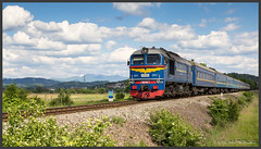
Zakarpattia Oblast (and ; Hungarian: Kárpátalja) is an oblast in western Ukraine, mostly coterminous with the historical region of Carpathian Ruthenia. Its administrative centre is the city of Uzhhorod, Other major cities within the oblast include Mukachevo, Khust, Berehove, and Chop, the last of which is home to railroad transport infrastructure.
Zakarpattia Oblast was established on 22 January 1946, after Czechoslovakia gave up its claim to the territory of Subcarpathian Ruthenia (Czech: Podkarpatská Rus) under a treaty between Czechoslovakia and the Soviet Union. The territory of Subcarpathian Ruthenia was then taken over by the USSR and became part of the Ukrainian SSR.
Some scholars say that during the Ukrainian independence referendum held in 1991, Zakarpatska Oblast voters were given a separate option on whether or not they favoured autonomy for the region. Although a large majority favoured autonomy, it was not granted. However, this referendum was about self-government status, not about autonomy (like in Crimea).
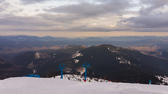
Situated in the Carpathian Mountains of western Ukraine, except the southwestern Hungarian-populated region that belongs to the Hungarian plain, Zakarpattia Oblast is the only Ukrainian administrative division which borders upon four countries: Poland, Slovakia, Hungary, and Romania. The Carpathians are an important tourist and travel destination housing many ski and spa resorts, meaning that they play a major part in the oblast's economy.
With a land area of almost , the oblast is ranked 23rd by area and 15th by population as according to the 2001 Ukrainian Census, the population of Zakarpatska Oblast was 1,254,614. The current population is This total includes people of many different nationalities of which Hungarians, Romanians, and Rusyns constitute significant minorities in some of the province's cities, while in others, they form the majority of the population (as in the case of Berehove).
Name
The oblast is also referred to as the Transcarpathian Oblast, Transcarpathia, Zakarpattia (Ukrainian: Закарпаття), or historically as Subcarpathian Rus'. In other languages the oblast is named:
- Hungarian: Kárpátalja, literally: "Base of the Carpathians"
- Slovak and Czech: Zakarpatská oblast; Podkarpatská Rus
- Polish: Obwód zakarpacki
- Romanian: Regiunea Transcarpatia (Romanian: [red͡ʒiˈune̯a transkarˈpat͡i.a])
- Ukrainian and Rusyn: Закарпатська область
While the name Transcarpathia is a translation of the Ukrainian version of the name, the Hungarian name translates as Subcarpathia, following the Hungarian language logic "feet of the mountains", naming a territory after its geographic location at the lower section of a mountain range. (Following the same language pattern that applies to the name of the sub-Alpian territory in Western Hungary, Alpokalja)
Generally, the Transcarpathia name and its versions reflect the East Slavic language logic, while some Western languages follow the same logic as the Hungarian:
- English: Subcarpathia, Subcarpathian Rus', Subcarpathian Ruthenia, Sub-Carpathian Ukraine
- French: Ukraine Subcarpathique
Other Western languages follow their own logic in creating a name for the region:
The coat of arms of Zakarpattia was originally created in the end of the 1920’s in the then Czechoslovakia.
Geography
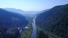
The Zakarpattia Oblast has a total area of and is located on southwestern slopes and foothills of the Carpathian Mountains covering around 80% of area in the region. The rest of the region is covered by the Transcarpathian Lowland which is part of the Pannonian plain. Zakarpattia is the only Ukrainian oblast to have boundaries with four countries: Poland, Slovakia, Hungary and Romania. On the West it borders the Prešov and Košice Regions of Slovakia and Borsod-Abaúj-Zemplén and Szabolcs-Szatmár-Bereg Counties of Hungary, on the South—the Satu Mare and Maramureș Counties of Romania, on the East and Northeast—Ivano-Frankivsk Oblast, and on the North—Lviv Oblast and the Subcarpathian Voivodeship of Poland.
The Zakarpattia Oblast mostly consists of mountains and small hills covered with deciduous and coniferous forests, as well as alpine meadows. Mountains cover about 80% of the oblast's area, and cross from North-West to South-East. The Primeval Beech Forests of the Carpathians, part of which are located within Zakarpattia Oblast, were recognized as a UNESCO World Heritage Site in 2007.
The largest rivers that flow through the oblast include the Tysa, Borzhava, and the Tereblia. A high altitude lake is located in Rakhiv Raion, which is the highest in the region. It is called Nesamovyte. The lake is located in the Hoverla preserve on the slopes of Turkul mountain. The lake's area is and it is located above sea level.
The region's climate is moderate and continental with about of rainfall per year. The average temperature in summer is +21 °С (70 °F) and −4 °С (25 °F) in winter. With an elevation of above sea level, Hoverla, part of the Chornohora mountain range, is the highest point in the oblast. The lowest point, above sea level, is located in the village of Ruski Heyevtsi (Oroszgejőc in Hungarian) in the Uzhhorodskyi Raion.
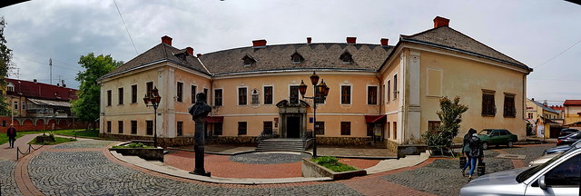
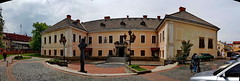
Four of the oblast's historical-cultural sites were nominated for the Seven Wonders of Ukraine competition in 2007: Palanok Castle, Museum upon the Chorna River, Mykhailiv Orthodox Church, and the Nevytsky Castle.
History
According to the Chronicon Pictum, the earliest state established in Zakarpattia was Ungvari in 677 AD. The name Ungvar derives from a migration of the Onogurs of Poltava who were ruled by the northern Kubiar sons of Kubrat. The Onogur tribes entered Etelköz through the Verecke Pass. Some of Ungvari's Kubiars under Khan-Tuvan eventually joined the Rus' to form Rus' Khaganate. In the late 9th century Ungvari's ruling Árpád dynasty began to fulfil their ambitions for the Carpathian basin where by 895 they had relocated to rule over the Magyars.
According to the Gesta Hungarorum, as Prince Álmos entered on the castle of Hung and there he appointed his son Árpád as the primary ruler, hence he was called of the leader of Hungvária, while all of his valiant soldiers as Hungvárus, so since then all the Magyars have been known by this name internationally.
In 895 the Hungarian tribes entered the Carpathian Basin from here through the Verecke pass, and the lands of Transcarpathia were influenced by the Principality of Hungary since 895, which transformed the Kingdom of Hungary in 1000. In Transcarpathia, the Voivodeship of Maramureș, granted to a small Romanian nobility, was established in 1343. The region was reorganized into the Máramaros County in 1402.
Since 1867, it was part of Hungarian side of Austria-Hungary until the latter's demise at the end of World War I. It approximately consisted of four Hungarian counties (comitatus): Bereg, Ung, Ugocsa and Maramaros. This region was briefly part of the short-lived West Ukrainian National Republic in 1918. The region was occupied by Romania by the end of that year, mostly the eastern portion such as Rakhiv and Khust. It was later recaptured by the Hungarian Soviet Republic in the summer of 1919. Finally, after the Treaty of Trianon of 1920 it became part of Czechoslovakia with a supposedly equal level of autonomy as the Slovak lands and Bohemia-Moravia-Czech Silesia (Czech lands).
The province has a unique footnote in history as the only region in the former Czechoslovakia to have had an American governor: its first governor was Gregory Zhatkovich, an American citizen who had earlier emigrated from the region and represented the Rusyn community in the U.S. Zhatkovich was appointed governor by Czechoslovakia's first president, T. G. Masaryk in 1920, and served for about one year until he resigned over differences regarding the region's autonomy. In 1928, it adopted the name of Subcarpathian Rus' (Czech: Podkarpatská Rus). Nevertheless, such autonomy was granted as late as in 1938, after detrimental events of the Munich Conference; until then this land was administered directly from Prague by the government-appointed provincial presidents () and/or elected governors ().
Following the Munich Agreement, the southern part of the region was awarded to Hungary under the First Vienna Award in 1938. The remaining portion was constituted as an autonomous region of the short-lived Second Czechoslovak Republic. After the Slovak declaration of an independent state on 14 March, the next day Carpatho-Ukraine was proclaimed as an independent republic but was immediately occupied and annexed by Hungary, and the Protectorate of Bohemia and Moravia was proclaimed a day after. Voloshyn asked support for recognition in advance from Hitler, but received no answer. The state is known as 'the one-day republic' because it did not exist more than one day. The military operations and the occupation of Carpatho-Ukraine was finished by the Hungarian troops on March 18.
The Hungarian invasion was followed by a few weeks of terror in which more than 27,000 people were shot dead without trial and investigation. Over 75,000 Ukrainians decided to seek asylum in the Soviet Union; of those almost 60,000 died in Gulag prison-camps. Others joined the Czechoslovak Army.
The major Jewish communities of the region had existed in Mukachevo, Ungvar, and Khust. During the German occupation of Hungary (March–December 1944), almost the entire Jewish population was deported; few survived the Holocaust.
In October 1944, the region was occupied by the Red Army. On 26 November 1944, the First Congress of People's Committees of Zakarpattia Ukraine took place in Mukachevo, and sham elections were organized on 10–25 November 1944. On 29 June 1945, Czechoslovak President Edvard Beneš, seeking to postpone the inevitable incorporation of Czechoslovakia into the Soviet Bloc, signed a treaty formally ceding the area to the Soviet Union, and the next month it was united with the Ukrainian SSR through the "Manifest for unification with Soviet Ukraine" that was …


Looking for places related to Zakarpats’ka Oblast’?
Those are other destinations to find places related to Zakarpats’ka Oblast’: