Zócalo

zocalo
Zócalo (Spanish: [ˈsokalo]) is the common name of the main square in central Mexico City. Prior to the colonial period, it was the main ceremonial center in the Aztec city of Tenochtitlan. The plaza used to be known simply as the "Main Square" or "Arms Square", and today its formal name is Plaza de la Constitución (Constitution Square). This name does not come from any of the Mexican constitutions that have governed the country but rather from the Cádiz Constitution, which was signed in Spain in the year 1812. Even so, it is almost always called the Zócalo today. Plans were made to erect a column as a monument to independence, but only the base, or zócalo (meaning "plinth"), was built. The plinth was buried long ago, but the name has lived on. Many other Mexican towns and cities, such as Oaxaca, Mérida, and Guadalajara, have adopted the word zócalo to refer to their main plazas, but not all.
It has been a gathering place for Mexicans since Aztec times, having been the site of Mexican ceremonies, the swearing-in of viceroys, royal proclamations, military parades, Independence ceremonies, and modern religious events such as the festivals of Holy Week and Corpus Christi. It has received foreign heads of state and is the main venue for both national celebrations and national protests. The Zócalo and surrounding blocks have played a central role in the city's planning and geography for almost 700 years. The site is just one block southwest of the Templo Mayor, which, according to Aztec legend and mythology, was considered the center of the universe.
Description
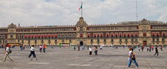
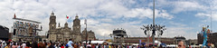
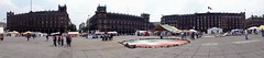
The modern Zócalo in Mexico City is 57,600 m2 (240 m × 240 m). It is bordered by the Mexico City Metropolitan Cathedral to the north, the National Palace to the east, the Federal District buildings to the south and the Old Portal de Mercaderes to the west, the Nacional Monte de Piedad building at the north-west corner, with the Templo Mayor site to the northeast, just outside view. In the centre is a flagpole with an enormous Mexican flag ceremoniously raised and lowered each day and carried into the National Palace. There is an entrance to the Metro station "Zócalo/Tenochtitlan" located at the north-east corner of the square but no sign above ground indicates its presence.
History
Pre-conquest
Prior to the conquest, the area that the occupies was open space, in the center of the Aztec capital . It was bordered to the east by 's "New Houses" or Palace (which would become the National Palace) and to the west by the "Old Houses", the palace of (1469–1481) where the Emperor , 's uncle and immediate predecessor also lived. A European-style plaza was not part of the conquered Aztec ; the old city had a sacred precinct or which was the absolute center of the city (and the universe, according to Aztec belief), but it was located to the immediate north and northeast of the modern-day .
The current occupies a space south-southwest of the intersection of roads that oriented . The north–south road was called (for the locations north and south it led to). The road led west and stretched east a little before leading into the lake that surrounded the city at the time. These roads were the width of three jousting lances according to . This intersection divided the city into four neighborhoods. The sacred precinct, containing the , was located to the northeast of this intersection and walled off from the open area for commoners. As to this area's relationship to the proper, some historians say that it was part of it, but others say no.
Viceroyalty of New Spain (1521–1821)
The modern plaza of Mexico City was placed by Alonso Garcia Bravo shortly after the invasion when he laid out what is now the historic center. After the destruction of Tenochtitlan, Cortés had the city redesigned for symbolic purposes. He kept the four major neighborhoods or "capullis" but he had a church, now the Cathedral of Mexico City, built at the place the four adjoined. He had the Temo become the cathedral. The southern half was called the "Plaza Mayor" (Main Square) and the northern one was called the "Plaza Chica" (Small Square). Fairly early in the colonial period, the Plaza Chica would be swallowed up by the growing city.
During early colonial times, the plaza was bordered to the north by the new church, and to the east by Cortés's new palace, built over and with the ruins of Moctezuma's palace. On the west side of the plaza, the Portales de Mercaderes (Merchants' Portals) were built, south of Cortés' other palace, the Palace of the Marquis of the Valley of Oaxaca. On the south side, was the Portal of the Flowers (Flores), named so after its owner, Maria Gutierrez Flores de Caballerias. Next to this portal was the House of the Ayuntamiento, a government building for the city. Both of these were behind a small drainage canal that ran east–west.
Flooding was always an issue for the plaza and the city in general. The plaza was flooded in 1629 with water two meters deep, ruining many of the merchants located there and requiring many of the portals to be rebuilt. The drainage project to control flooding, known as the desagüe, drafted Indian men over nearly the whole colonial period, to work on this major infrastructure project. Controlling flooding meant health benefits for Mexico City residents by preventing human waste from polluting the city during floods and controlling mosquitoes, which spread disease. It also changed the ecological system that supported birds and fish populations and allowed for Indian cultivation of crops.
After the cathedral was constructed in the latter half of the 16th century, the look of the plaza changed. The old church faced east and not to the plaza itself. The new cathedral's three portals towered south over the plaza and giving the area a north–south orientation, which exists to this day.
Over much of the 17th century, the plaza became overrun with market stalls. After a mob burned the Viceregal Palace in 1692, depicted in the famous 1696 painting by Cristóbal de Villalpando, authorities attempted to completely clear the plaza to make way for the "Parian", a set of shops set in the southwest corner of the plaza used to warehouse and sell products brought by galleons from Europe and Asia. This was opened in 1703. The Parián is shown at the bottom of Villalpando's painting; it was later destroyed in an 1828 riot.
This, however, did not keep the rest of the plaza from becoming filled again with makeshift stalls such as the group known as "San José" located next to the Parian itself. This prompted historian Francisco Sedano to comment that it was ugly and unsightly. He claimed it was very difficult to walk around here at the time because of its uneven pavement, mud in the rainy season, aggressive street dogs, mounds of trash and human excrement tossed among the corn husks and other discarded wrappings.
Again the plaza was cleared (with exception of the Parian) by proclamation of Charles IV of Spain in December 1789. Then-viceroy Juan Vicente Güemes Pacheco had the plaza repaved and the open gutters covered with stone blocks. He also had a fountain installed in each corner. During this work, the Aztec Calendar was unearthed, as well as a statue of the goddess Coatlicue. The Calendar was put on display on the west side of the cathedral, where it remained until about 1890 when it was moved to the old "Centro Museum". It now resides in the Museum of Anthropology. The statue eventually made its way to this museum, but not until it was practically buried in one of the back patios of the Royal and Pontifical University until after Independence. The former merchants of the plaza were moved primarily to a new building called the Mercado de Volador (Market of the Flyer), located southeast of the plaza where the Supreme Court building stands today.
The plaza was converted into a public space with 64 lamps. The cathedral was separated from the plaza by iron grating; 124 stone benches were placed and the plaza was marked off by low iron poles connected by an iron chain. The main feature of the redesigned plaza was an equestrian statue of Charles IV by Manuel Tolsá. It was first placed in the southeastern corner of the plaza, first on a gilded wood base to inaugurate it in December 1803. When the monument was finished, the wooden base was replaced by an oval one of stone measuring 113 meters by 95.5 meters, with its own balustrade and fountains at the corners created by José del Mazo.
This was the backdrop when Viceroy Don Felix Maria Calleja, other authorities and assembled people swore allegiance to the Constitution of Cadiz, and fealty to the Spanish Crown on 22 May 1813 as the Mexican War of Independence raged. This event also resulted in renaming the square as the "Plaza of the Constitution." The last changes to the plaza before Independence in 1821 were done by Manuel Tolsá placing the Cross of Mañozca at the southeast corner and placing another, similar cross to the northwest. Both of these were set on stone Neoclassical pedestals.
Independence and the 1828 Parián Riot
A symbolic move upon Independence was the dismantling and removal of the equestrian monument to Charles IV from Plaza. The statue itself can still be seen in front of the National Art Museum where its current, and much smaller, base states that it is preserved solely for its artistic value. The statue's former oval base was moved to what was then the university building and the balustrade was moved to the Alameda Central. This left the plaza bare except for the Parian.
On 4 and 5 December 1828, the Parián market, the most active of Mexico City's markets, was looted and damaged by a popular uprising. Several merchants died and most were ruined. President Santa Anna finally had the Parián demolished in 1843. This left the plaza bare again, except for some ash trees and flower gardens that were planted and protected by stone borders. Santa Anna wanted to build a monument to Mexican Independence in the center of the plaza but hi…


Looking for places related to Zócalo?
Those are other destinations to find places related to Zócalo:
- Mexico City Metropo…
- Torre Latinoamerica…
- Zócalo
- Mexico City Alameda…
- National Palace
- Templo Mayor
- Museo Nacional de A…
- Santo Domingo
- Monumento a La Raza
- Hemiciclo a Juárez
- Museo del Estanquil…
- Correos de México
- Edificio Miguel E. …
- Edificio La Nacional
- Secretariat of Fore…
- Basilica of Our Lad…
- San Pedro y San Pab…
- Franz Mayer Museum
- Bank of Mexico
- Secretariat of Publ…
- Callejón de Manzana…
- Interactive Museum …
- Colegio Nacional
- Café de Tacuba