Cocos Islands

The Cocos (Keeling) Islands , officially the Territory of Cocos (Keeling) Islands (;), are an Australian external territory in the Indian Ocean, comprising a small archipelago approximately midway between Australia and Sri Lanka and relatively close to the Indonesian island of Sumatra. The territory's dual name (official since the islands' incorporation into Australia in 1955) reflects that the islands have historically been known as either the Cocos Islands or the Keeling Islands.
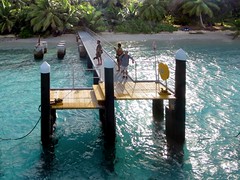
The territory consists of two atolls made up of 27 coral islands, of which only two – West Island and Home Island – are inhabited. The population of around 600 people consists mainly of Cocos Malays, who mostly practice Sunni Islam and speak a dialect of Malay as their first language. The territory is administered by the Australian federal government's Department of Infrastructure, Transport, Regional Development and Communications as an Australian external territory and together with Christmas Island (which is about to the east) forms the Australian Indian Ocean Territories administrative grouping. However, the islanders do have a degree of self-government through the local shire council. Many public services – including health, education, and policing – are provided by the state of Western Australia, and Western Australian law applies except where the federal government has determined otherwise. The territory also uses Western Australian postcodes.
The islands were discovered in 1609 by the British sea captain William Keeling, but no settlement occurred until the early 19th century. One of the first settlers was John Clunies-Ross, a Scottish merchant; much of the island's current population is descended from the Malay workers he brought in to work his copra plantation. The Clunies-Ross family ruled the islands as a private fiefdom for almost 150 years, with the head of the family usually recognised as resident magistrate. The British annexed the islands in 1857, and for the next century they were administered from either Ceylon or Singapore. The territory was transferred to Australia in 1955, although until 1979 virtually all of the territory's real estate still belonged to the Clunies-Ross family.
Name
The islands have been called the Cocos Islands (from 1622), the Keeling Islands (from 1703), the Cocos–Keeling Islands (since James Horsburgh in 1805) and the Keeling–Cocos Islands (19th century). Cocos refers to the abundant coconut trees, while Keeling refers to William Keeling, who discovered the islands in 1609.
John Clunies-Ross, who sailed there in the Borneo in 1825, called the group the Borneo Coral Isles, restricting Keeling to North Keeling, and calling South Keeling "the Cocos properly so called". The form Cocos (Keeling) Islands, attested from 1916, was made official by the Cocos (Keeling) Islands Act 1955.
The territory's Malay name is Pulu Kokos (Keeling). Sign boards on the island also feature Malay translations.
Geography
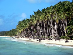
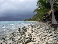
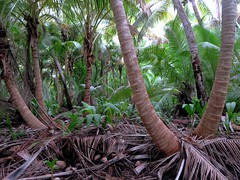
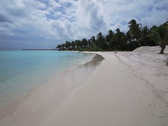
The Cocos (Keeling) Islands consist of two flat, low-lying coral atolls with an area of , of coastline, a highest elevation of and thickly covered with coconut palms and other vegetation. The climate is pleasant, moderated by the southeast trade winds for about nine months of the year and with moderate rainfall. Tropical cyclones may occur in the early months of the year.
North Keeling Island is an atoll consisting of just one C-shaped island, a nearly closed atoll ring with a small opening into the lagoon, about wide, on the east side. The island measures in land area and is uninhabited. The lagoon is about . North Keeling Island and the surrounding sea to from shore form the Pulu Keeling National Park, established on 12 December 1995. It is home to the only surviving population of the endemic, and endangered, Cocos Buff-banded Rail.
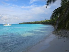
South Keeling Islands is an atoll consisting of 24 individual islets forming an incomplete atoll ring, with a total land area of . Only Home Island and West Island are populated. The Cocos Malays maintain weekend shacks, referred to as pondoks, on most of the larger islands.
| Islet (Malay name) | Translation of Malay name | English name | Area (approx) | ||
| km2 | mi2 | ||||
| 1 | Pulau Luar | Outer Island | Horsburgh Island | ||
| 2 | Pulau Tikus | Mouse Island | Direction Island | ||
| 3 | Pulau Pasir | Sand Island | Workhouse Island | ||
| 4 | Pulau Beras | Rice Island | Prison Island | ||
| 5 | Pulau Gangsa | Copper Island | Closed sandbar, now part of Home Island | ||
| 6 | Pulau Selma | Home Island | |||
| 7 | Pulau Ampang Kechil | Little Ampang Island | Scaevola Islet | ||
| 8 | Pulau Ampang | Ampang Island | Canui Island | ||
| 9 | Pulau Wa-idas | Ampang Minor | |||
| 10 | Pulau Blekok | Reef Heron Island | Goldwater Island | ||
| 11 | Pulau Kembang | Flower Island | Thorn Island | ||
| 12 | Pulau Cheplok | Cape Gooseberry Island | Gooseberry Island | ||
| 13 | Pulau Pandan | Pandanus Island | Misery Island | ||
| 14 | Pulau Siput | Shell Island | Goat Island | ||
| 15 | Pulau Jambatan | Bridge Island | Middle Mission Isle | ||
| 16 | Pulau Labu | Pumpkin Island | South Goat Island | ||
| 17 | Pulau Atas | Up Wind Island | South Island | ||
| 18 | Pulau Kelapa Satu | One Coconut Island | North Goat Island | ||
| 19 | Pulau Blan | East Cay | |||
| 20 | Pulau Blan Madar | Burial Island | |||
| 21 | Pulau Maria | Maria Island | West Cay | ||
| 22 | Pulau Kambing | Goat Island | Keelingham Horn Island | ||
| 23 | Pulau Panjang | Long Island | West Island | ||
| 24 | Pulau Wak Bangka | Turtle Island | |||
There are no rivers or lakes on either atoll. Fresh water resources are limited to water lenses on the larger islands, underground accumulations of rainwater lying above the seawater. These lenses are accessed through shallow bores or wells.
Demographics
According to the 2021 Australian Census, the current population of the Cocos Islands is 593 people. The median age of the population is 40 years, slightly older than the median Australian population age of 38 years. As of 2021, there are no people living on the Cocos Islands who identify as Indigenous Australians (Aboriginal or Torres Strait Islander).
The majority religion of the Cocos Islands is Islam, with 65.6% of the total population identifying as Muslim, followed by Unspecified (15.3%), Non-religious (14.0%), Catholic (2.0%), Anglican (1.5%). The remaining 1.6% of Cocos Islanders identify as secular or hold various other beliefs (including atheism, agnosticism and unspecified spiritual beliefs).
73.5% of the population were born in Australia - either on the mainland, on the Cocos Islands, or in another Australian territory. The remaining 26.5% born outside of Australia come from various countries, including Malaysia (4.0%), England (1.3%), New Zealand (1.2%), Singapore (0.5%) and Argentina (0.5%), among others. 61.2% of the population speak Malay rather than English at home, while 19.1% use English as their primary language and 3.5% speak another language (including Spanish and various Austronesian and African languages).
Kaum Ibu (Women's Group) is a women's rights organisation that represents the view of women at a local and national level.
History
Discovery and early history
The archipelago was discovered in 1609 by Captain William Keeling of the East India Company, on a return voyage from the East Indies. North Keeling was sketched by Ekeberg, a Swedish captain, in 1749, showing the presence of coconut palms. It also appears on a 1789 chart produced by British hydrographer Alexander Dalrymple.
In 1825, Scottish merchant seaman Captain John Clunies-Ross stopped briefly at the islands on a trip to India, nailing up a Union Jack and planning to return and settle on the islands with his family in the future. Wealthy Englishman Alexander Hare had similar plans, and hired a captain coincidentally, Clunies-Ross's brotherto bring him and a volunteer harem of 40 Malay women to the islands, where he hoped to establish his private residence. Hare had previously served as resident of Banjarmasin, a town in Borneo, and found that "he could not confine himself to the tame life that civilisation affords".
Clunies-Ross returned two years later with his wife, children and mother-in-law, and found Hare already established on the island and living with the private harem. A feud grew between the two. Clunies-Ross's eight sailors "began at once the invasion of the new kingdom to take possession of it, women and all".
After some time, Hare's women began deserting him, and instead finding themselves partners amongst Clunies-Ross's sailors. Disheartened, Hare left the island. He died in Bencoolen in 1834. Encouraged by members of the former harem, Clunies-Ross then recruited Malays to come to the island for work and wives.
Clunies-Ross's workers were paid in a currency called the Cocos rupee, a currency John Clunies-Ross minted himself that could only be redeemed at the company store.
On 1 April 1836, under Captain Robert FitzRoy arrived to take soundings to establish the profile of the atoll as part of the survey expedition of the ''Beagle''. To the naturalist Charles Darwin, aboard the ship, the results supported a theory he had developed of how atolls formed, which he later published as The Structure and Distribution of Coral Reefs. He studied the natural history of the islands and collected specimens. Darwin's assistant Syms Covington noted that "an Englishman was in fact Scottish and HIS family, with about sixty or seventy mulattos from the Cape of Good Hope, live on one of the islands. Captain Ross, the governor, is now absent at the Cape."
Annexation by the British Empire
The islands were annexed by the British Empire in 1857. This annexation was carried out by Captain Stephen Grenville Fremantle in command of . Fremantle claimed the islands for the British Empire and appointed Ross II as Superintendent. In 1878, by Letters Patent, the Governor of Ceylon was made Governor of the islands, and, by further Letters Patent in 1886, responsibility for the islands was transferred to the Governor of the Straits Settlement to exercise his functions as "Governor of Cocos Islands".
The islands were made part of the Straits Settlement under an Order in Council of 20 May 1903. Meanwhile, in 1886 Queen Victoria had, by indenture, granted the islands in perpetu…