Cromwell

Mount Difficulty
Cromwell (Māori: Tīrau) is a town in Central Otago region of the South Island of New Zealand. Cromwell is located on the shores of Lake Dunstan where the Kawarau river joins Lake Dunstan. Cromwell was established during the Otago gold rush and is now more known as one of the sub regions of the Central Otago wine region. In 2018, the town of Cromwell was home to a population of 5610 people.
Geography
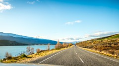
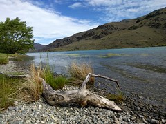
Cromwell is between (linking to Wānaka, north, and Queenstown via the Kawarau Gorge, west) and State Highway 8 leading to the Lindis Pass, northeast, and Alexandra, 33 km south. The road to Alexandra winds through the Cromwell Gorge. A point near Cromwell lies 119 kilometres from the sea, the farthest from the sea anywhere in New Zealand. A prominent feature surrounding much of the town is the man-made Lake Dunstan.
Cromwell is surrounded by the Pisa mountain range to the north (including Mount Pisa, 1963 metres) the Dunstan mountains to the northeast (including Mount Dunstan, 1667 metres) Mount Difficulty (1285 metres) to the west and the Old Woman Range and Cairnmuir mountains to the south.
Nearby settlements are at Bannockburn, Lowburn, Tarras, and Ripponvale.
Cromwell has a strategic location between the Lindis and the Haast passes, and acts as a hub between the towns of Wānaka, Queenstown and Alexandra.
Cromwell is also the home of the Cromwell Chafer Beetle (Prodontria lewisi).
The 45th parallel south runs just north of the township.
Cromwell lay at the confluence of the Clutha River and the Kawarau River, which was noted for the difference between the colours of the waters of the two rivers and also for the historic bridge at the convergence of the two. Since the construction of the Clyde Dam and the filling of Lake Dunstan in the early 1990s the river confluence was drowned, as was the old town centre.
History
European exploration of the area first occurred in September 1853 by Nathaniel Chalmers. Further explorations occurred in the late 1850s with detailed surveys occurring in 1861.
In 1862, gold was discovered below the Junction by two miners, Horatio Hartley and Christopher Reilly. Once the word of a gold strike was out, there was an influx of several thousand miners to the area as well as supporting nine hotels in Cromwell.
Cromwell was originally known as "The Junction", being at the confluence of the Clutha River / Mata-Au and the Kawarau River. It was renamed Cromwell in the middle of 1863 by J. A. Connell (of the Dunedin firm Connell and Moodie) who was from Northern Ireland because of "a silly rivalry between a Northern Irish surveyor and Southern Irish miners" based in the district. Cromwell was declared a municipality in 1866. The government funded the construction of a bridge across the Clutha in 1866 (which cost 28,000 pounds). This was rebuilt in 1891. Bishop Selwyn visited in 1866. Cromwell's newspaper, The Cromwell Argus, was established in 1869. The Cromwell council chambers were completed in 1869 and the Cromwell district hospital was established in 1875 with wards to provide beds for ten inpatients.
The population was 424 people in 1878 and increased to 429 people in 1881. Gold mining by individuals was replaced by dredging by companies in the 1890s. but was short lived. The population decreased with smaller scale mining activities continuing until the 1930s. The Cromwell railway station, connecting Cromwell to Dunedin was opened in July 1921. It burnt down in 1942 and was subsequently rebuilt. it was closed in 1976 with the railway line from Clyde to Cromwell being closed in 1980.
Soldiers from Cromwell served in World War 1 with 13 losing their lives. A cenotaph was unveiled on 25 April 1923 to recognise their sacrifice. A further 11 soldiers from Cromwell died during World War II. A memorial hall was built in the 1950s which is dedicated to those fallen in the two World Wars.
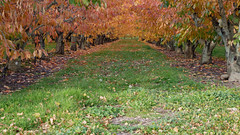
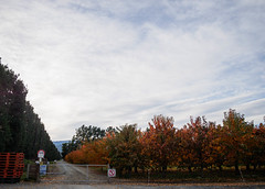
As gold ran out, Cromwell became the service centre for an extensive farming and stone fruit growing area. An irrigation scheme was built in the 1920s diverting water from the Kawarau river to irrigate a large area of land near Ripponvale.
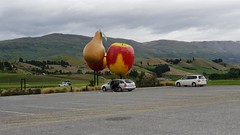
The stone fruit industry is commemorated with the giant sculpture of stone fruit which stands outside the northern end of the town. It was built by the Cromwell Rotary Club in 1990 with the design coming from Otto Muller. The sculpture is regularly repainted.
The decision to build Clyde Dam and use Cromwell as the accommodation base brought many changes to the town. In the early stages, a government information centre in Cromwell was set on fire in a late-night attack.
Approximately one-third of the town was rebuilt on higher ground. A total of 60 homes and 50 commercial properties were affected. The changes included the doubling of the residential area, relocation of the old town centre (now called "Old Cromwell Town"), upgrading of services, and the provision of modern educational and sports facilities, and a new bridge. The town centre was relocated between 1984 and 1985 to a new site known as "The Mall," that now houses the main retail, service and civic buildings in Cromwell. Several of the old buildings of the town which escaped the flooding have been retained as a historic precinct close to the shore of the Kawarau.
The lake started to fill in autumn of 1992 with 2000 hectares including farmland and 17 orchards also being flooded by Lake Dunstan.
The town was named after Oliver Cromwell and, as well as "The Junction", the town was previously known as "The Point" and "Kawarau".
Cromwell is nicknamed the "Fruit Bowl of the South".
Amenities
Cromwell museum
The Cromwell museum was established in the 1960s. It had to relocate in 1988 due to its original location being due to be flooded by the filling of Lake Dunstan. It is currently located at 47 The Mall. Its collections include Chinese artefacts (which tell of the history of the Chinese gold miners in the region), moa bones, domestic and agricultural items and photographs of Cromwell.
Cromwell swimming pool
The Cromwell swimming pool was built in the 1980s. It was upgraded in 2007. Located on Barry Avenue, the indoor complex contains a 25-metre pool, a learners' pool and a toddler's pool.
Kiwi water park
The Kiwi water park is located five minutes outside of Cromwell on state highway 6. The park containing various inflatable obstacles, water toys and diving boards. It attracted 30,000 visitors in the summer of 2021/22. There was doubt that it would open for the 2022 / 23 summer season due to traffic safety issues entering the park but a resolution was achieved.
Cromwell public library
The Cromwell public library is located at 43 The Mall. It is open six days each week and is administered by Central Otago and Queenstown Lakes Library consortia. The library has wifi, computer facilities and wheelchair access as well as a range of fiction and non – fiction books, magazines and DVDs.
Historic places
Cromwell heritage precinct
The construction of the Clyde Dam created Lake Dunstan, which consumed part of the old Cromwell town. Some of the historic buildings were saved or rebuilt to create the heritage precinct. Near the precinct is the Cromwell Kilwinning Lodge No.98 which was built in 1869.
Former St John's Presbyterian church
Presbyterian church services where first held in Cromwell by the 1860s. In the 1870s, fundraising took place to build a church. The St John's Presbyterian church was designed by F.W. Burwell in a gothic style and built by Grant and Mackellar out of local schist stone. The church hall was added in 1913. The church closed in 2004 and was sold. The building is a category two historic place.
Mary Immaculate and the Irish Martyrs Catholic church
The Mary Immaculate and the Irish Martyrs Catholic church was opened in April 1909. The church has a 20 metre tall belltower with an orange tiled roof. At the time of its opening, it was described as "far and away the handsomest building in Cromwell". The church was named in recognition of the Irish Catholic gold-miners living in the town.
St Andrew's Anglican church
St Andrew's Anglican church was opened in 1874. It was designed in a Gothic style. The site for the church was chosen when Bishop Samuel Tarratt Nevill visited in 1873. John Marsh, a local Cromwell resident donated the land for the church and the church cost 700 pounds to build. The Ladies Guild raised 150 pounds of the cost in 1874. Leadlight windows were installed in the east and west ends in 1893. A pipe organ was installed in 1919. Electricity was installed in the church in 1926 and the church hall was built in 1932.
Athenaeum hall
The Athenaeum Hall was built in 1874. It was used to house the Cromwell Museum until 1988 and then earthworks from the building of Lake Dunstan left it three quarters buried. Work (including stonemasonry) was being completed in 2017 to stabilise the remaining walls.
Litany Street cemetery
The Litany Street cemetery was Cromwell's first cemetery and was established in 1865. This cemetery is the resting place for a number of the early Cromwell gold miners. A number of the early Chinese immigrants who came to Cromwell in search of gold are also buried here. In the early 1900s a second cemetery was created and is known as the new Cromwell cemetery.
Former Cromwell courthouse
The Cromwell courthouse was built by William Grant (a carpenter) and James Ritchie (a stonemason) and was completed in 1872. It was used at the courthouse in Cromwell for over one hundred years. It is now privately owned. It is a category two Historic Place.
Bannockburn
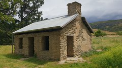
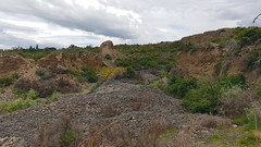
Bannockburn is located 5.8 km south of Cromwell via Bannockburn road. It is possible to walk to Bannockburn via the 11 kilometre Cromwell to Bannockburn lakeside walk. Bannockburn is a small town which was once the centre of a gold mining industry. Historic buildings include the hotel, post office, Stewart's store, and a number of homes. Next to the town of Bannockburn are the Bannockburn sluicings. These include dams, tunnels, water races and shafts created during…


Looking for places related to Cromwell?
Those are other destinations to find places related to Cromwell: