Maidan Nezalezhnosti
Maidan Nezalezhnosti (Ukrainian: Майдан Незалежності Ukrainian: [mɐjˈdɑn nezɐˈlɛʒnosʲtʲi], literally "Independence Square") is the central square of Kyiv, the capital city of Ukraine. One of the city's main squares, it is located on Khreshchatyk Street in the Shevchenko Raion. The square has been known under many different names, but often it is called by people simply Maidan ("square"). The square contains the iconic Independence Monument.
In the 19th century, the square contained buildings of the city council and noble assembly.
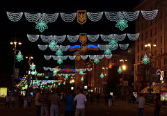
Since the start of Ukraine's independence movement in 1990, the square has been the traditional place for political rallies, including four large-scale radical protest campaigns: the 1990 student Revolution on Granite, the 2001 Ukraine without Kuchma, the 2004 Orange Revolution and the 2013–14 Euromaidan. Maidan is also a regular site for non-political displays and events; however, since 2014, most of them were moved to Sofiyivska Square or elsewhere, because making entertainment on a place where people were killed during Euromaidan was considered inappropriate. Most notably, Christmas Fairs and New Year celebrations were moved to Sofiyivska Square.
Names
The square received its current name on 26 August 1991, two days after the Declaration of Independence of Ukraine, during the collapse of the Soviet Union. Maidan is a Ukrainian word for "square, open space", with widely used equivalents in the Middle East and South Asia to refer to an open space in or near a town, used as a parade ground or for events such as public meetings. It comes from Persian ("town-square or central place of gathering"), itself deriving from Proto-Iranian, ultimately from Proto-Indo-European . Compare Avestan , Sanskrit and Latin . The word also was borrowed into neighboring Turkic languages, as in the Crimean Tatar and Turkish , which are the likely sources of the borrowing into Ukrainian.
is the only square in Kyiv officially designated as a "Maidan" in the Ukrainian language, as all remain designated as a "Ploscha" (a more common Ukrainian equivalent of "square") as was used during Soviet rule. In the Russian language as spoken in Ukraine, it is also the only use of the word “Maidan” (Майдан) for a public square.
Timeline of the square's names:
- 1869: Khreshchatyk Square (Khreshchatitskaya ploshchad)
- 1876: Parliament Square (Dumskaya ploshchad)
- 1919: Soviet Square (Sovetskaya ploshchad)
- 1935: Kalinin Square (Ploshchad Kalinina)
- 1941: Parliament Square (Dumska ploshcha)
- 1943: Kalinin Square (Ploshchad Kalinina)
- 1977: Square of the October Revolution (Russian: Ploshchad Oktyabrskoi Revolutsyi, Ukrainian: Ploshcha Zhovtnevoyi revolyutsii)
- 1991: Independence Square (Maidan Nezalezhnosti)
City squares called are also found in Khmelnytskyi and Sumy. Kropyvnytskyi, Kremenchuk and Odesa have "Independent Squares" named (using rather than for "square").
Location
Independence Square is one of three squares located along Khreshchatyk, close to the northeastern end of the street. It is situated close to European Square, which is the terminal end of Khreshchatyk. Besides Khreshchatyk, which splits the square in half, several other streets lead to the square. These include Architect Horodecki Street, Institute Street, Michael Street, Kosciol Street, Minor Zhytomyr Street, Sophia Street, Taras Shevchenko Lane, and Boris Hrinchenko Street.
The square itself is a multi-level location. At ground level is the intersection of Khreshchatyk, which splits Institute Street (vulytsia Instytutska), and Michael Street (vulytsia Mykhailivska). Underneath the square, the Obolonsko–Teremkivska line of the Kyiv Metro stretches across with its station Maidan Nezalezhnosti located underground. Also the "Hlobus" mall is situated underneath the square.
History
Early history and Tsarist Russia
Until the 10th century, the future square's site, as well as the rest of Khreshchatyk, was called Perevisyshch. It was located just to the south of the Kyiv City, beyond which were located territories of the Cave Monastery (Kyiv-Pechersky) along the Dnipro River.
At the lower end of Sofiivska vulytsia (Sofia Street), which led to the High City, stood one of the three main gates of Old Kyiv (Yaroslav's City), the Lyadski Gates; the other two were the Golden Gates and Zhydivski Gates. Those gates are also mentioned in 1151, and around them lived the Polish population of the city, Lacka Sloboda. The Lyadksi Gates were destroyed during the storm of city by the Mongol army of Batu Khan in 1240.
Sometime during the 18th century, the new Pecherski Gates were erected; they stood until 1833. Until the early 19th century, the area was a low-lying vacant ground known as Goat Swamp (Kozyne Boloto).
In the 1830s, the first wooden dwellings were built on the site, and in the 1850s stone buildings appeared. The most famous Ukrainian writer, Taras Shevchenko lived in that area in 1859, in a building between Mala Zhytomyrska (Little Zhytomyr) and Mykhailivska vulytsia (Michael's Street).
Development rapidly intensified after the mid-19th century, when the territory gradually became the commercial center of Kyiv, which underwent an immense boom during the Russian Industrial Revolution, becoming the third most important city in the Russian Empire. Until 1871, it was called the Khreshchatitskaya Ploshchad (Khreshchatyk Square); it was a location for the local market and folk entertainment. In 1876, the Kyiv City Duma building was built here, and the area became known as the Dumskaya Ploshchad (Duma Square). A line from the Kyiv tram, the first electric tram built in the Russian Empire (opened 1892) reached the square in 1894.
In 1913, in front of the City Duma, a monument of Pyotr Stolypin (who was assassinated in Kyiv in 1911) was constructed, and it stood there until March 1917 at the dawn of the Revolutionary war within the Empire.
Soviet prewar years
In 1919, the square was renamed Soviet Square. From 1935, it was called Kalinin Square, after Mikhail Kalinin, the first chairman of the Supreme Soviet of the USSR.
Soviet postwar years
During the first couple of years after the war, the square was completely rebuilt from scratch. It was architecturally integrated with the newly constructed Khreshchatyk in the typical (for the time) neo-classical Stalinist architecture. The newly constructed Kyiv Central Post Office and Trade-Union House with its high-rise clock located in the square, is very well known and frequently appears in pictures of the center of the city.
In 1976-77, as a part of metro construction, much of the square was again rebuilt, and it was renamed October Revolution Square (Ploshcha Zhovtnevoyi revolyutsii). During the reconstruction, the massive cubist monument to commemorate the 60th anniversary of the October Revolution was put up as was the complex ensemble of fountains.
During the Soviet period, the square was used for demonstrations and parades in honor of May 1 (until 1969), Victory Day and the October Revolution.
Independent Ukraine
After Ukraine's independence in 1991, the square was given its current name. The competing proposal of Liberty Square (Ploshcha Svobody) was raised at the time as well as in the years to follow, but the current name commemorating the Ukrainian independence is now firmly associated with the square (see the section below).
In 2001, as the square was the major center of the "Ukraine without Kuchma" mass protest campaign, the new extensive construction of the area was abruptly ordered by the Kyiv mayor of the time, Oleksandr Omelchenko. The square was fenced off for construction and became inaccessible for the protesters and many observers claimed that the main goal of the project ordered by the city mayor was to disrupt the protests, especially since similar tactics were commonly used by local authorities throughout Ukraine.
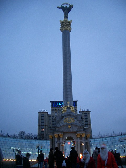
Following the construction, the old familiar look of the square, with its many fountains, was significantly altered and the public reaction to the new look of the square was mixed at first. However, by now the square's monument to Kyi, Shchek, Khoryv and Lybid, the legendary founders of Kyiv, the folklore hero Cossack Mamay, the city's historic protector Archangel Michael as well as a more modern invention, the protecting goddess Berehynia surmounting the Independence Monument victory column commemorating the independence of Ukraine, and the many glass domes are easily recognisable as parts of the modern city centre.
A mostly underground shopping mall called Globus was built under the square to replace the old and shabby giant underpass formerly dubbed by Kyivans as "Truba" (the Tube).
Trade-Unions House was severely damaged during the fire in February 2014, so later it went through a reconstruction.
Future developments of the square include the demolition of the old "Ukrayina" hotel (formerly hotel "Moskva"), and building a new 68-floor building instead.
Landmarks
Current landmarks
- Monument to the Founders of Kyiv
- Independence Monument, a victory column commemorating the independence of Ukraine in 1991, surmounted by the protectoress Berehynia
- Lach Gates
Former landmarks
- Monument to Pyotr Stolypin
- Bust to Karl Marx
- Monument to the Great October (Lenin)
Important buildings
- "Hlobus", subsequently Globus ("Globe") underground shopping mall
- Tchaikovsky National Music Academy of Ukraine
- Hotel Ukraine
- Building of the Trade Unions Federation of Ukraine
- Central Post Office
External links
- Майдан Незалежності in ''Wiki-Encyclopedia Kyiv''
Places Maidan Nezalezhnosti


Looking for places related to Maidan Nezalezhnosti?
Those are other destinations to find places related to Maidan Nezalezhnosti:
- Saint Sophia's Cath…
- St. Michael's Golde…
- A.V. Fomin Botanica…
- St Volodymyr's Cath…
- Maidan Nezalezhnosti
- St Andrew's Church,
- House with Chimaeras
- Golden Gate,
- National University…
- Andriyivskyy Descent
- Parus Business Cent…
- Arsenalna
- House of the Weepin…
- Verkhovna Rada
- Cabinet of Ukraine
- Contracts House
- PinchukArtCentre
- Teatralna
- Farmacia-Museo de
- Bessarabska Square
- Central Council of …
- Borychiv Descent
- Building of Pedagog…
- Museum of Western a…