The Burren
The Burren (English: /ˈbən/ ;) is a karst/glaciokarst landscape centred in County Clare, on the west coast of Ireland. It measures around , within the circle made by the villages of Lisdoonvarna, Corofin, Gort and Kinvara. The area includes such natural features as Mullaghmore hill and Ailladie cliffs, and historic monuments such as Poulnabrone dolmen and Caherconnell Stone Fort. The Burren National Park covers a small part of the Burren and is the smallest of the six National Parks in Ireland, while the adjacent territory, including the Cliffs of Moher, is included in the Burren and Cliffs of Moher Geopark.
Location
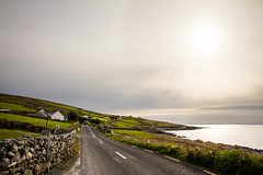
While the name is generally applied to the limestone uplands of northwestern Clare, and adjacent lowlands, and generally excludes the area of Clare shales to the southwest, the exact extent of the area is not clearly defined, and geologically it does extend into County Galway to both the north and northeast (see Geology below). The southeastern pocket of Co. Galway around Kinvara is usually included, and is the base for many Burren organisations. The Burren is bounded by the Atlantic Ocean and by Galway Bay, with the Aran Islands representing a geological extension of the limestone hills that make up most of The Burren.
According to one definition, the Burren extends south to a line from the coastal resort of Lahinch to Corofin and is delimited in the east by a line roughly from Kinvara to Kilmacduagh monastery, near Gort. Note that taken literally, this would includes places like the town of Ennistymon and the Cliffs of Moher, which would more commonly be considered as neighbouring the Burren. In another definition, the agriculture focused "Burren Programme" defines the region as extending well into the Gort plain, encompassing inter alia Coole Park and the turloughs around it, while to the south it would extend to Ruan and Crusheen, and in the southwest to the edge of Doolin, as well as the routine Lisdoonvarna, Kilfenora and Corofin.
Thus the stated size of the Burren varies between around (the core area of exposed limestone), through (taking in all limestone landscapes) and 560 square kilometers (including the about of downland), depending on the approach taken. Roughly 60% of the uplands show exposed limestone pavement.
Geology
Stratigraphy
The area is formed from a thick succession of sedimentary rocks, largely limestones but also including sandstones, mudstones and siltstones. All of the solid rocks exposed at the surface are of Carboniferous age though they are underlain at depth by Old Red Sandstone of Devonian age which in turn overlies rocks of Lower Palaeozoic age. None of the pre-Carboniferous rocks is seen at the surface in the area. The limestones, which date from the Visean stage of the early Carboniferous, formed as sediments in a tropical sea approximately 325 million years ago. The strata contain fossil corals, crinoids, sea urchins and ammonites. This bed of limestone is up to 800 metres thick. In the north and west it lies on a shelf of Galway granite which supported the upper layers, preventing shifts like those that created the "twisted" hills Knockanes and Mullaghmore. The limestone also extends below Galway Bay out to the Aran Islands and to the east into the Gort plain.
Later in the Carboniferous (c. 318 million years ago), the limestone was covered by darker sand and mud that later turned into shale (the lower "Clare Shales") and sandstone (the upper "Millstone Grit"). These layers reached a thickness of up to in north Clare. These top layers protected the underlying limestone from erosion for millions of years before being largely stripped away by glaciers, except in the south west, where they still extend from Doolin to Slieve Elva, Lisdoonvarna, Kilfenora and to the western shore of Lake Inchiquin. One "island" of shale is the hill Poulacapple, southwest of Ballyvaughan, where an upland moor has formed on top of the impermeable shale layers.
The local geological succession comprises the following formations some of which are subdivided into various members. The youngest rocks are at the start of the list, the oldest at the bottom. The first three listed are of Namurian age and are a mix of mudstones, sandstones and siltstones, the remainder are Visean age limestones.
- Central Clare Group
- Gull Island Formation
- Clare Shale Formation
- Slievenaglasha Formation
- Lissylisheen Member
- Ballyelly Member
- Fahee North Member
- Balliny Member
- Burren Formation
- Ailwee Member
- Maumcaha Member
- Hawkhill Member
- Fanore Member
- Black Head Member
- Tubber Formation
- Finavarra Member
- Castlequarter Member
- Newtown Member
- Fiddaun Member
- Cregmahon Member
Quaternary
Glaciation during the late Quaternary period (beginning c. one million years ago) facilitated greater denudation. Glaciers expanded and retreated over the region several times. Of the last two periods the first was the more pronounced, covering the whole of the Burren. The last advance of the ice cover was more limited, affecting only the eastern Burren.
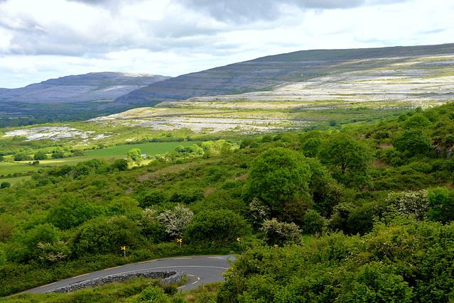
The result is that the Burren is one of the finest examples of glacio-karst landscape in the world. The effects of the last glacial period (the Midlandian) are most in evidence, with the Burren overrun by ice during this glaciation. The impact of earlier karstification (solutional erosion) has been eliminated by the last glacial period. So any surface karstification now seen dates from approximately 10,000 years ago and the Burren karst is thus very recent in geological terms.
Solutional processes have widened and deepened the grikes of the limestone pavement. Pre-existing lines of weakness in the rock (vertical joints) contribute to the formation of extensive fissures separated by clints (flat pavement like slabs). The rock karstification facilitates the formation of subterranean drainage. This has formed numerous cave systems of which more than 50 kilometres have been mapped. The most accessible of these is Aillwee Cave.
Due to the processes mentioned, there are very few permanent surface rivers in the region. The Caher, flowing into the sea at Fanore, is one of the most stable. Some of the large valleys, mostly running south to north, that are still visible today are in fact the remains of pre-glacial river valleys. The rivers disappeared from the surface when the upper layers of stone had been stripped away.
Another characteristic feature of the Burren is closed roughly circular depressions with no surface outlets for water (called poljes). Around 100 of these exist, mostly in the eastern Burren. The most notable are the valleys of Kilcorney, Poulawilan, Caherconnel and Carran, generally stretching from northeast to southwest. The largest is the Carran depression, more than two miles long, up to a mile wide and over 200 feet deep. This is where the pre-glacial rivers of the area first eroded away the upper layers and started to dissolve the exposed limestone. Some of the smaller ones were created when caves underneath collapsed (one example of this is the Glen of Clab).
Glaciers also deposited numerous granite and limestone erratics on the pavements. The former were carried south across Galway Bay by the second-to-last glaciation. Granite boulders can be found mostly in the north of the Burren. The final ice cover came from the northeast and mostly deposited limestone erratics. On Slieve Elva these are visible today at elevations of up to mabove sea level. The characteristic terracing of the hills occurred when vertical joints weathered and large blocks of limestone fell off and were further eroded away.
Towards the very end of the Ice Age the glaciers ended for a time at Fanore. At that time, Slieve Elva and Knockauns hill alone rose above the surrounding ice fields. The valleys facing Galway Bay had been widened considerably by glacial action, first when the ice moved south from Connemara and then when meltwater sought a runoff. When the ice finally retreated it also left moraines in valley bottoms and the characteristic drumlins (most of them on top of the shale and sandstone to the south). The Caher Valley was almost choked up by deposited sand and rocks and these also piled up against the western slopes of Slieve Elva. It was this protective layer of sediment that has made surface streams locally possible once more.
Today, the uplands' highest point is on the hill Slieve Elva, whose shale cover rises up to above sea level.
Landscape types and habitats
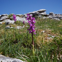
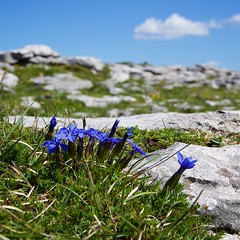
In addition to the limestone pavement, major landscape types, providing the habitats for the flora and fauna, include limestone heath, dry calcareous grasslands, calcareous (calcifying or petrifying) springs, the intermittent water bodies called turloughs, bogs, cladium fens, lakes, wet grasslands, scrub and light woodland, and neutral, and farm-improved, grasslands.
History
Prehistory
Archaeological evidence from cave finds of butchered bones have been radiocarbon dated to 33,000 years ago, showing evidence of hunters during the Ice Age.
Pollen analysis indicates that in the Mesolithic period of 8000 to 7000 BC The Burren looked completely different from today, with most of the uplands covered in a mixture of deciduous, pine and yew trees. No clear evidence of Mesolithic settlements or camp sites in the area has yet been discovered. At the limits of the region, near Lake Inchiquin and at the so-called "Doolin Axe Factory", stone artifacts have been discovered that may be Mesolithic in origin. However, by the Neolithic, c. 4000 BC, settlers had clearly arrived and began changing the landscape through deforestation, likely by overgrazing and burning, and the building of stone walls. These people also constructed Megalithic sites like the portal tomb known as Poulnabrone dolmen and the court tombs at Teergonean (near Doolin) and Ballyganner (near Noughaval). Overall, there are around 70 megalithic tombs in the Burren area, more than half of all of these structures found in Clare.
The most numerous type of prehistoric structure (apart from stone walls) in The Burren is the la…


Looking for places related to The Burren?
Those are other destinations to find places related to The Burren: